IMAGES TAKEN NEAR TO
Coton Hayes, Milwich, STAFFORD, ST18 0HB
Introduction
This page details the photographs taken nearby to ST18 0HB by members of the Geograph project.
The Geograph project started in 2005 with the aim of publishing, organising and preserving representative images for every square kilometre of Great Britain, Ireland and the Isle of Man.

There are currently over 7.5m images from over14,400 individuals and you can help contribute to the project by visiting https://www.geograph.org.uk
Image Map
Images are licensed for reuse under creativecommons.org/licenses/by-sa/2.0
Notes
- Clicking on the map will re-center to the selected point.
- The higher the marker number, the further away the image location is from the centre of the postcode.
Image Listing (6 Images Found)
Images are licensed for reuse under creativecommons.org/licenses/by-sa/2.0
Image
Details
Distance
2
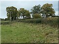
Hedge and trees near Coton House Farm
Early November, and the trees are just beginning to turn.
Image: © Christine Johnstone
Taken: 2 Nov 2020
0.22 miles
3
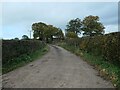
Access track to Coton House Farm
On the north side of the B5027.
Image: © Christine Johnstone
Taken: 2 Nov 2020
0.22 miles
4
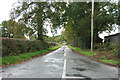
Minor Road leaving the Uttoxeter Road towards Fradswell Heath
Image: © Mick Malpass
Taken: 30 Oct 2011
0.24 miles
5
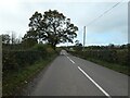
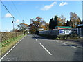
B5027, heading west at Coton Hayes
About to pass the wonderfully-named Spon Drumble Farm.
Image: © Christine Johnstone
Taken: 2 Nov 2020
0.24 miles
6
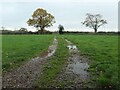
Farm track heading south from the B5027
Giving access to the field beyond the hedge.
Image: © Christine Johnstone
Taken: 2 Nov 2020
0.24 miles