IMAGES TAKEN NEAR TO
Salt, STAFFORD, ST18 0BW
Introduction
This page details the photographs taken nearby to ST18 0BW by members of the Geograph project.
The Geograph project started in 2005 with the aim of publishing, organising and preserving representative images for every square kilometre of Great Britain, Ireland and the Isle of Man.

There are currently over 7.5m images from over14,400 individuals and you can help contribute to the project by visiting https://www.geograph.org.uk
Image Map (Loading...)


Getting Data...Please wait
Leaflet Map data © OpenStreetMap
Images are licensed for reuse under creativecommons.org/licenses/by-sa/2.0
Notes
- Clicking on the map will re-center to the selected point.
- The higher the marker number, the further away the image location is from the centre of the postcode.
Image Listing (39 Images Found)
Images are licensed for reuse under creativecommons.org/licenses/by-sa/2.0
Image
Details
Distance
1
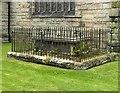
Church of St James the Great, Salt
Stubbs family monument, chest tomb in a railed enclosure, mid 19th century. The family lived at nearby Weston Hall.
Image: © Alan Murray-Rust
Taken: 16 Aug 2017
0.03 miles
2
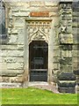
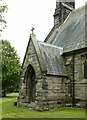
Church of St James the Great, Salt
The priest's door on the south side, with elaborate decoration.
Image: © Alan Murray-Rust
Taken: 16 Aug 2017
0.03 miles
3
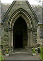
Church of St James the Great, Salt
The south porch.
Image: © Alan Murray-Rust
Taken: 16 Aug 2017
0.03 miles
4

Village Hall, Salt
The hall is a former wooden First World War army hut. Over the years the wooden side walls had decayed and were replaced in stages with brick. The final section on this side of the hall was completed in 2013.
Image: © Alan Murray-Rust
Taken: 16 Aug 2017
0.03 miles
5
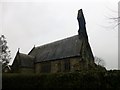
Church of St James the Great, Salt
The east end of the church looks more like a traditional west end, which is rather disorienting.
Image: © Alan Murray-Rust
Taken: 16 Aug 2017
0.03 miles
6
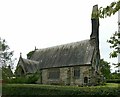
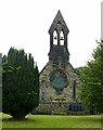
Church of St James the Great, Salt
View of the church from the south. The bellcote is at the east end of the church.
Image: © Alan Murray-Rust
Taken: 16 Aug 2017
0.03 miles
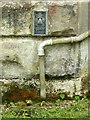
7
Church of St James the Great, Salt
The vestry, designed to look like a traditional south porch. There is a bench mark http://www.geograph.org.uk/photo/5507383 just to the left of the doorway.
Image: © Alan Murray-Rust
Taken: 16 Aug 2017
0.04 miles
8
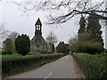
Church of Salt St James the Great, Salt
Built 1840-42, largely at the expense of the 16th Earl of Shrewsbury
Image: © Tim Heaton
Taken: 27 Mar 2017
0.04 miles
9
St. James The Great Church, Salt
The Parish church St James the Great and its vicarage was built on land donated by the Earl of Shrewsbury. He also financed the building and it was constructed with stone taken from the Earls own quarry at Weston Bank. The church houses a wooden screen designed by the eminent Victorian architect Augustus Pugin and was formerly part of the furnishings of the private chapel at Alton Towers, one time home of the Earls of Shrewsbury.
Image: © Rude Health
Taken: 30 Mar 2015
0.04 miles
10
Flush bracket bench mark, St James's Church, Salt
See http://www.geograph.org.uk/photo/5507387 for location.
Image: © Alan Murray-Rust
Taken: 16 Aug 2017
0.04 miles