IMAGES TAKEN NEAR TO
Beaconside, STAFFORD, ST18 0AQ
Introduction
This page details the photographs taken nearby to Beaconside, ST18 0AQ by members of the Geograph project.
The Geograph project started in 2005 with the aim of publishing, organising and preserving representative images for every square kilometre of Great Britain, Ireland and the Isle of Man.

There are currently over 7.5m images from over14,400 individuals and you can help contribute to the project by visiting https://www.geograph.org.uk
Image Map (Loading...)


Getting Data...Please wait
Leaflet Map data © OpenStreetMap
Images are licensed for reuse under creativecommons.org/licenses/by-sa/2.0
Notes
- Clicking on the map will re-center to the selected point.
- The higher the marker number, the further away the image location is from the centre of the postcode.
Image Listing (13 Images Found)
Images are licensed for reuse under creativecommons.org/licenses/by-sa/2.0
Image
Details
Distance
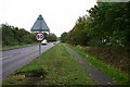
2
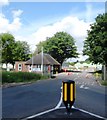
Beacon Farm Entrance, Beaconside, Stafford
Notice the public footpath sign, on one side it has got Doorstep Walk, What is a doorstep walk?
Image: © Mick Malpass
Taken: 17 Jul 2011
0.11 miles
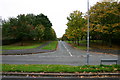
3
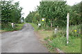
Portal Rd
Portal Road, junction with Salmond Avenue, Stafford. Behind the trees to the right is the very busy Beaconside Road next to the 'retired' RAF station.
Image: © Stephen Pearce
Taken: 23 Oct 2006
0.13 miles
4
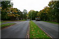
Beaconside looking northwest
Beaconside at Stafford. On the left of the bend is Portal Road, access road to what was primarily RAF housing. To the right behind the hedge is RAF Stafford.
Image: © Stephen Pearce
Taken: 23 Oct 2006
0.14 miles
5
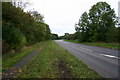
Beaconside looking towards the A518, Stafford
Beaconside looking towards the A518, Stafford. In the distance can be seen the new Stafford Technology park, a very large development bringing lots of businesses and jobs to Stafford.
Image: © Stephen Pearce
Taken: 23 Oct 2006
0.15 miles
6
Salmond Avenue, Stafford
Salmond Avenue looking up the street - you may just work out the top of the District General Hospital in the background. The road across the foreground is Portal Road.
Image: © Stephen Pearce
Taken: 23 Oct 2006
0.15 miles
7
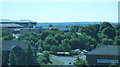
View of Cannock Chase, from Stafford Technology Park
View from top floor of Enterprise offices on Stafford Technology Park. The tower in distance is on the Chase.
Image: © Michael Westley
Taken: 21 Jun 2010
0.15 miles
8
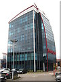
Victory Point, Stafford
On Staffordshire Technology Park, offices for Enterprise Management Services
Image: © Michael Westley
Taken: 5 Oct 2011
0.19 miles
9
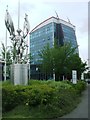
Victory Point
Nelson looks out in front of Victory Point. Image has been re-branded following merger of the business with Amey owned by the Spanish Ferrovial Group.
The sculptures were a feature of the number of developments by Pritchard Holdings together with the tinted glass. The developers parent company went into administration in 2011.
Image: © John M
Taken: 6 Jul 2016
0.19 miles
10
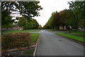
Salmond Avenue, Stafford
The area used to be housing for RAF staff but is largely sold off to private occupiers or Health Service staff.
Image: © Stephen Pearce
Taken: 23 Oct 2006
0.20 miles