IMAGES TAKEN NEAR TO
West Way, STAFFORD, ST17 9ZL
Introduction
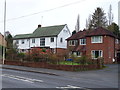
This page details the photographs taken nearby to West Way, ST17 9ZL by members of the Geograph project.
The Geograph project started in 2005 with the aim of publishing, organising and preserving representative images for every square kilometre of Great Britain, Ireland and the Isle of Man.

There are currently over 7.5m images from over14,400 individuals and you can help contribute to the project by visiting https://www.geograph.org.uk
Image Map
Images are licensed for reuse under creativecommons.org/licenses/by-sa/2.0
Notes
- Clicking on the map will re-center to the selected point.
- The higher the marker number, the further away the image location is from the centre of the postcode.
Image Listing (2 Images Found)
Images are licensed for reuse under creativecommons.org/licenses/by-sa/2.0
Image
Details
Distance
1
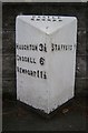
Old Milepost by the A518, Newport Road, Stafford
Cast iron post by the A518, in parish of Stafford (Stafford District), Newport Road, East of West Way and West of Stafford town centre, in path in front of stone wall, on South side of road. Lathe iron casting, erected by the County Council in the 19th/20th century.
Inscription reads:-
: HAUGHTON 3½ / GNOSALL 6 / NEWPORT 11½ : : CASTLE / CHURCH : : STAFFORD 1 :
Maker:-
: Chas. Lathe, Tipton. :
Staffordshire HER.
HER Number: 51343 https://www.heritagegateway.org.uk/Gateway/Results_Single.aspx?uid=MST12566&resourceID=1010
Milestone Society National ID: ST_STNP01
Image: © J Higgins
Taken: 1 Jan 2000
0.19 miles