IMAGES TAKEN NEAR TO
Merrivale Road, STAFFORD, ST17 9EN
Introduction
This page details the photographs taken nearby to Merrivale Road, ST17 9EN by members of the Geograph project.
The Geograph project started in 2005 with the aim of publishing, organising and preserving representative images for every square kilometre of Great Britain, Ireland and the Isle of Man.

There are currently over 7.5m images from over14,400 individuals and you can help contribute to the project by visiting https://www.geograph.org.uk
Image Map (Loading...)


Getting Data...Please wait
Leaflet Map data © OpenStreetMap
Images are licensed for reuse under creativecommons.org/licenses/by-sa/2.0
Notes
- Clicking on the map will re-center to the selected point.
- The higher the marker number, the further away the image location is from the centre of the postcode.
Image Listing (12 Images Found)
Images are licensed for reuse under creativecommons.org/licenses/by-sa/2.0
Image
Details
Distance
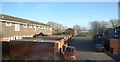
2
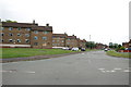
Hawksmoor Road, off Merrivale Road, Stafford
Image: © Mick Malpass
Taken: 27 Jun 2011
0.16 miles
5
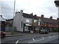
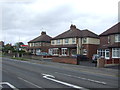
Newsagents and houses, Rising Brook, Stafford
Image: © JThomas
Taken: 10 Aug 2019
0.19 miles
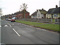
7
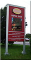
Sign for the Royal Oak, Stafford
See Image] for context.
Image: © JThomas
Taken: 10 Aug 2019
0.20 miles
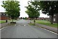
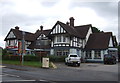
9
Dual use path beside Rising Brook (A449), Stafford
Image: © JThomas
Taken: 10 Aug 2019
0.24 miles