IMAGES TAKEN NEAR TO
Kingsley Road, STAFFORD, ST17 9BU
Introduction
This page details the photographs taken nearby to Kingsley Road, ST17 9BU by members of the Geograph project.
The Geograph project started in 2005 with the aim of publishing, organising and preserving representative images for every square kilometre of Great Britain, Ireland and the Isle of Man.

There are currently over 7.5m images from over14,400 individuals and you can help contribute to the project by visiting https://www.geograph.org.uk
Image Map
Images are licensed for reuse under creativecommons.org/licenses/by-sa/2.0
Notes
- Clicking on the map will re-center to the selected point.
- The higher the marker number, the further away the image location is from the centre of the postcode.
Image Listing (16 Images Found)
Images are licensed for reuse under creativecommons.org/licenses/by-sa/2.0
Image
Details
Distance
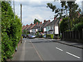
2
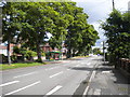
West end of Kingsley Road, Rising Brook
Image: © Richard Vince
Taken: 22 Jun 2015
0.09 miles
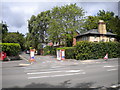
3
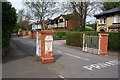
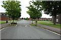
The St Johns Road entrance to the Rowley Park Estate
A private estate where visitors are warned that they may be turned back at any time.
Image: © Bill Boaden
Taken: 2 Apr 2011
0.11 miles
4
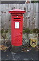
George V postbox on Rising Brook, Stafford
Postbox No. ST17 36.
Image: © JThomas
Taken: 10 Aug 2019
0.12 miles
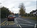
5
South east end of St John's Road, Rising Brook
The entrance to a private estate from the A449 Rowley Bank.
Image: © Richard Vince
Taken: 22 Jun 2015
0.12 miles
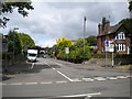
7
East end of Highfield Grove, Rising Brook
Seen from the A449 Rowley Bank.
Image: © Richard Vince
Taken: 22 Jun 2015
0.14 miles
8
East end of Park Avenue, Rising Brook
Seen from the A449 Rowley Bank.
Image: © Richard Vince
Taken: 22 Jun 2015
0.19 miles
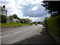
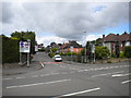
10
South end of Rowley Bank, Rising Brook
Looking towards Stafford town centre from just north of the junction with West Way.
Image: © Richard Vince
Taken: 22 Jun 2015
0.20 miles