IMAGES TAKEN NEAR TO
Basil Close, STAFFORD, ST17 4UW
Introduction
This page details the photographs taken nearby to Basil Close, ST17 4UW by members of the Geograph project.
The Geograph project started in 2005 with the aim of publishing, organising and preserving representative images for every square kilometre of Great Britain, Ireland and the Isle of Man.

There are currently over 7.5m images from over14,400 individuals and you can help contribute to the project by visiting https://www.geograph.org.uk
Image Map
Images are licensed for reuse under creativecommons.org/licenses/by-sa/2.0
Notes
- Clicking on the map will re-center to the selected point.
- The higher the marker number, the further away the image location is from the centre of the postcode.
Image Listing (13 Images Found)
Images are licensed for reuse under creativecommons.org/licenses/by-sa/2.0
Image
Details
Distance
3
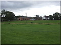
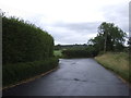
Rickerscote Hall
Down the bottom of Rickercote Hall Lane.
Image: © David Bagshaw
Taken: 12 Dec 2005
0.13 miles
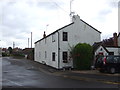
4
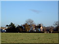
Rickerscote Hall Lane
Towards Rickerscote Hall Farm.
Image: © JThomas
Taken: 10 Aug 2019
0.14 miles
6
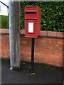
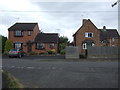
Elizabeth II postbox on Rickerscote Road, Stafford
Postbox No. ST17 181.
See Image] for context.
Image: © JThomas
Taken: 10 Aug 2019
0.15 miles
7
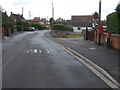
Rickerscote Road, Stafford
Showing position of Postbox No. ST17 181.
See Image] for postbox.
Image: © JThomas
Taken: 10 Aug 2019
0.16 miles
9
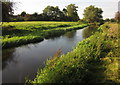
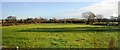
River Penk
Flowing between meadows across its flood plain.
Image: © Derek Harper
Taken: 6 Sep 2012
0.20 miles