IMAGES TAKEN NEAR TO
The Downs, STAFFORD, ST17 4NP
Introduction
This page details the photographs taken nearby to The Downs, ST17 4NP by members of the Geograph project.
The Geograph project started in 2005 with the aim of publishing, organising and preserving representative images for every square kilometre of Great Britain, Ireland and the Isle of Man.

There are currently over 7.5m images from over14,400 individuals and you can help contribute to the project by visiting https://www.geograph.org.uk
Image Map
Images are licensed for reuse under creativecommons.org/licenses/by-sa/2.0
Notes
- Clicking on the map will re-center to the selected point.
- The higher the marker number, the further away the image location is from the centre of the postcode.
Image Listing (23 Images Found)
Images are licensed for reuse under creativecommons.org/licenses/by-sa/2.0
Image
Details
Distance
1
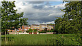
Wildwood Park Sports Fields and housing, Stafford
Seen from the Staffordshire and Worcestershire Canal. The housing is in Hartsbourne Way, off Wildwood Drive.
Image: © Roger Kidd
Taken: 28 Jul 2015
0.05 miles
2
Wildwood Park Sports Fields and housing, Stafford
Seen from the Staffordshire and Worcestershire Canal. The housing is in Hartsbourne Way, off Wildwood Drive.
Image: © Roger Kidd
Taken: 28 Jul 2015
0.05 miles
3
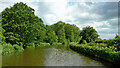
Staffordshire and Worcestershire Canal south-east of Stafford
This section of the canal is narrow due to the encroaching trees. Wildwood Park football pitches are behind the trees on the left.
The canal was opened in 1772, engineered by James Brindley. It joins the River Severn at Stourport to the Trent and Mersey Canal at Great Haywood Junction in Staffordshire. There are 43 locks (45 if you don't fancy the deep wide locks at Stourport) and the canal is 46 miles in length.
Image: © Roger D Kidd
Taken: 31 May 2011
0.12 miles
4
Staffordshire and Worcestershire Canal near Wildwood Park
Image: © David Martin
Taken: 31 Jul 2015
0.13 miles
5
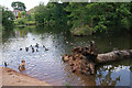
Wildmoor nature pond
There has been a lot of housing development nearby but this pond on the edge of the marshy valley of the Penk has been preserved.
Image: © Bill Boaden
Taken: 7 Jul 2019
0.14 miles
6
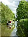
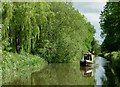
Cruising on the Staffordshire and Worcestershire Canal near Stafford
Looking south as the canal meanders towards Acton Trussell and Penkridge. Wildwood Park is off to the left. Radford Meadows are off to the right. The hire boat is from Stone, and is called "Frances".
Image: © Roger Kidd
Taken: 31 May 2011
0.15 miles
7
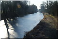
Frozen Staffordshire and Worcestershire Canal
It was a bright frosty morning and I wasn't able to filter out the effect of the sun.
Image: © Bill Boaden
Taken: 11 Feb 2012
0.15 miles
8
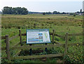
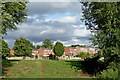
Radford Meadows Nature Reserve
This information board is next to the towpath of the Staffordshire & Worcestershire Canal.
Image: © Mat Fascione
Taken: 18 Aug 2016
0.16 miles
9
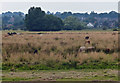
Radford Meadows Nature Reserve
Looking west from the towpath of the Staffordshire & Worcestershire Canal.
The houses in the distance are in the Rickerscote area of Stafford.
Image: © Mat Fascione
Taken: 18 Aug 2016
0.17 miles
10
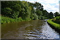
Staffordshire and Worcestershire Canal near Wildwood, Stafford
Looking south towards Acton Trussell, Penkridge, and Wolverhampton. Wildwood Park is ahead, off to the left. Radford Meadows are off to the right.
Image: © Roger Kidd
Taken: 31 May 2011
0.18 miles