IMAGES TAKEN NEAR TO
Garden Street, STAFFORD, ST17 4BT
Introduction
This page details the photographs taken nearby to Garden Street, ST17 4BT by members of the Geograph project.
The Geograph project started in 2005 with the aim of publishing, organising and preserving representative images for every square kilometre of Great Britain, Ireland and the Isle of Man.

There are currently over 7.5m images from over14,400 individuals and you can help contribute to the project by visiting https://www.geograph.org.uk
Image Map
Images are licensed for reuse under creativecommons.org/licenses/by-sa/2.0
Notes
- Clicking on the map will re-center to the selected point.
- The higher the marker number, the further away the image location is from the centre of the postcode.
Image Listing (105 Images Found)
Images are licensed for reuse under creativecommons.org/licenses/by-sa/2.0
Image
Details
Distance
1
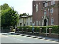
St Joseph's Convent, Lichfield Road, Stafford
Nursing home for the elderly run by the Sisters of St Joseph of Cluny.
The further part of the building, originally Forebridge Villa, dates from c.1810 and is Listed Grade II.
Image: © Alan Murray-Rust
Taken: 23 Aug 2017
0.09 miles
2
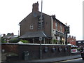
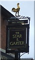
The Star & Garter, Stafford
On Wolverhampton Road.
Image: © JThomas
Taken: 10 Aug 2019
0.11 miles
3
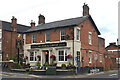
The Star & Garter, Stafford
On Wolverhampton Road.
Image: © JThomas
Taken: 10 Aug 2019
0.11 miles
4
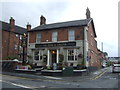
The Star and Garter public house, Wolverhampton Road, Stafford
The Star and Garter public house is on the junction of Wolverhampton Road (A449) and Park Street. It is part of the Dorbiere Pub Group. According to its website the building dates back to the 1820s and over 30 craft gins are served.
Image: © Rod Grealish
Taken: 15 Jul 2024
0.11 miles
5
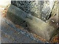
Bench mark, St Paul's Church, Lichfield Road, Stafford
Pivot style mark, see http://www.geograph.org.uk/photo/5511580 for location.
Image: © Alan Murray-Rust
Taken: 23 Aug 2017
0.11 miles
7
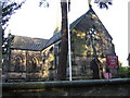
St. Paul's Church, Forebridge, Stafford
This church is sited on the busy A34.
Image: © Angella Streluk
Taken: 28 Oct 2005
0.12 miles
8
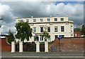
Green Hall, Lichfield Road, Stafford
A large Regency period house, built c.1810, originally known as Forebridge Hall. Stuccoed brick with pilasters and Ionic porch, Listed Grade II. After a period as council offices, it has recently been converted to apartments. The surrounding wall and gateway are separately Listed Grade II.
Image: © Alan Murray-Rust
Taken: 23 Aug 2017
0.12 miles
9
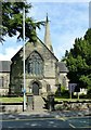
St Paul's Church, Lichfield Road, Stafford
Built in 1844, Henry Ward, architect, the spire being added in 1887. A classic Victorian Gothic church, using Early English features. Listed Grade II.
The churchyard wall and gateway are separately Listed Grade II.
There is a bench mark http://www.geograph.org.uk/photo/5511576 on the right hand gatepost.
Image: © Alan Murray-Rust
Taken: 23 Aug 2017
0.12 miles
10
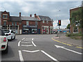
Queensway roundabout traffic lights
On south side of roundabout heading for A518
Image: © John Firth
Taken: 13 Jul 2011
0.12 miles