IMAGES TAKEN NEAR TO
Middle Friars, STAFFORD, ST17 4AE
Introduction
This page details the photographs taken nearby to Middle Friars, ST17 4AE by members of the Geograph project.
The Geograph project started in 2005 with the aim of publishing, organising and preserving representative images for every square kilometre of Great Britain, Ireland and the Isle of Man.

There are currently over 7.5m images from over14,400 individuals and you can help contribute to the project by visiting https://www.geograph.org.uk
Image Map
Images are licensed for reuse under creativecommons.org/licenses/by-sa/2.0
Notes
- Clicking on the map will re-center to the selected point.
- The higher the marker number, the further away the image location is from the centre of the postcode.
Image Listing (297 Images Found)
Images are licensed for reuse under creativecommons.org/licenses/by-sa/2.0
Image
Details
Distance
2
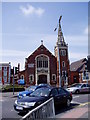
Stafford Baptist Church
It has a strange skeletal spire and the street light makes it look like a radar
Image: © Eirian Evans
Taken: 4 Jun 2005
0.03 miles
3
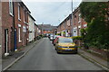
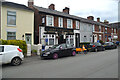
Jubilee Cottages, Friars Road, Stafford
Image: © Chris Whippet
Taken: 19 Jun 2014
0.04 miles
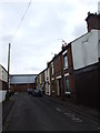
5
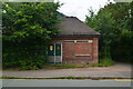
Electricity Sub-station, Friars' Terrace, Stafford
An operational electricity sub-station. The sub-station was built before nationalisation probably in the 1920's. The light brown concrete panels above the door top would have read Corporation Electricity Department - the corporation being Stafford Borough Council. The left-most panel has been replaced by a longer lintel for the modern green doors; the words on the other two panels have been covered by concrete.
Image: © Rod Grealish
Taken: 15 Jul 2024
0.05 miles
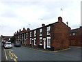
6
View South along Orchard Street, Stafford
Looking south along Orchard Street to Park Street. The roof of St Austin's Catholic Church can be seen on the skyline
Image: © Rod Grealish
Taken: 15 Jul 2024
0.07 miles
7
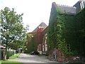
Ivy covered building, Newport Rd
Victorian brick building at the head of Newport Road. Formerly a school, now used by the education authority.
Image: © David Neill
Taken: 1 Sep 2006
0.07 miles
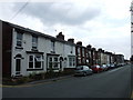
9
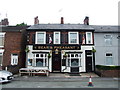
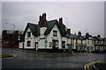
The Bear and Pheasant public house, Friars' Terrace, Stafford
A traditional pub situated in a terrace of houses. OS maps show that the buildings were here by 1889.
Image: © Rod Grealish
Taken: 15 Jul 2024
0.07 miles
10
The White Lion
Lichfield Road to the right and White Lion Street to the left (now a cul-de-sac). The main Lichfield Road has been redirected and now travels around the back of these buildings. The white building used to be the White Lion public house but is now a small business outlet.
Image: © Stephen Pearce
Taken: 27 May 2007
0.07 miles