IMAGES TAKEN NEAR TO
Cannock Road, STAFFORD, ST17 0YY
Introduction
This page details the photographs taken nearby to Cannock Road, ST17 0YY by members of the Geograph project.
The Geograph project started in 2005 with the aim of publishing, organising and preserving representative images for every square kilometre of Great Britain, Ireland and the Isle of Man.

There are currently over 7.5m images from over14,400 individuals and you can help contribute to the project by visiting https://www.geograph.org.uk
Image Map (Loading...)


Getting Data...Please wait
Leaflet Map data © OpenStreetMap
Images are licensed for reuse under creativecommons.org/licenses/by-sa/2.0
Notes
- Clicking on the map will re-center to the selected point.
- The higher the marker number, the further away the image location is from the centre of the postcode.
Image Listing (5 Images Found)
Images are licensed for reuse under creativecommons.org/licenses/by-sa/2.0
Image
Details
Distance
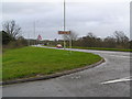
1
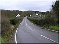
Brocton Gate Farm and road to Bednall Belt Plantation
Road into Cannock Chase as it leaves the A34 at SJ 96533 18724
Image: © Jack Barber
Taken: 2 Jan 2007
0.04 miles
2
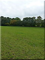
Field and footpath near Brocton Gate Farm
The fingerpost for the path pointed more or less directly across this field, and there appears to be a gate & stile on the far side under the trees. But precious little sign of the path being used much, to be honest.
Image: © Richard Law
Taken: 18 Oct 2020
0.05 miles
4
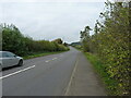
Road into Cannock Chase as it leaves A34 at Brocton
Road to Commonwealth and German War Cemetery on Cannock Chase
Image: © Jack Barber
Taken: 2 Jan 2007
0.18 miles
5
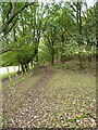
Footpath north of Meadows Farm
A pleasant track from Camp Road up through the edge of beech woods towards Oldacre and the Tar Hill area of Cannock Chase.
Image: © Richard Law
Taken: 18 Oct 2020
0.21 miles