IMAGES TAKEN NEAR TO
Brocton Road, STAFFORD, ST17 0UH
Introduction
This page details the photographs taken nearby to Brocton Road, ST17 0UH by members of the Geograph project.
The Geograph project started in 2005 with the aim of publishing, organising and preserving representative images for every square kilometre of Great Britain, Ireland and the Isle of Man.

There are currently over 7.5m images from over14,400 individuals and you can help contribute to the project by visiting https://www.geograph.org.uk
Image Map (Loading...)


Getting Data...Please wait
Leaflet Map data © OpenStreetMap
Images are licensed for reuse under creativecommons.org/licenses/by-sa/2.0
Notes
- Clicking on the map will re-center to the selected point.
- The higher the marker number, the further away the image location is from the centre of the postcode.
Image Listing (54 Images Found)
Images are licensed for reuse under creativecommons.org/licenses/by-sa/2.0
Image
Details
Distance
1
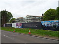
New care home being constructed on Brocton Road
Image: © JThomas
Taken: 18 May 2019
0.04 miles
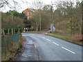
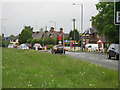
4
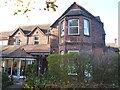
Sister Dora Convalescent Hospital
The hospital was opened by the Bishop of Lichfield in April 1884. The hospital was funded by the proceeds of the biography by Margaret Lonsdale of Sister Dora the pioneering nurse in nearby Walsall from 1865 to 1878.
The hospital took wounded soldiers at the outbreak of the Great War. until a large 1000 bed military hospital was built at Brindley Heath.
The camp railway for Brocton and Rugeley Camps, 'the Tackeroo', was constructed through the hospital grounds.
The hospital continued until the 1970s and much extended is currently a care home.
Image: © John M
Taken: 30 Nov 2013
0.06 miles
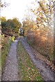
5
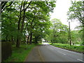
Brocton Road towards the A513
Looking north.
Image: © JThomas
Taken: 18 May 2019
0.11 miles
6
Milford edge of Cannock Chase
The building in front is Sister Dora's retirement home.
Image: © David Bagshaw
Taken: 1 Jan 2007
0.11 miles
7
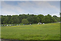
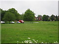
Milford Common
The cars visible are in a car park at the edge of Milford Common, which stretches off to the top and right of the picture.
Image: © Malcolm Neal
Taken: 20 May 2017
0.14 miles
8
Milford Common, Cannock Chase
A general view of Milford Common and car park.
Image: © Tim Marshall
Taken: Unknown
0.14 miles
9
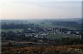
Milford Common
Looking towards the south with the Barley Mow Public House behind the right shoulder
Image: © David Bagshaw
Taken: 21 May 2006
0.14 miles
10
Barley Mow at Milford
On the corner of Milford Common
Image: © David Bagshaw
Taken: 21 May 2006
0.14 miles