IMAGES TAKEN NEAR TO
Porlock Avenue, STAFFORD, ST17 0HS
Introduction
This page details the photographs taken nearby to Porlock Avenue, ST17 0HS by members of the Geograph project.
The Geograph project started in 2005 with the aim of publishing, organising and preserving representative images for every square kilometre of Great Britain, Ireland and the Isle of Man.

There are currently over 7.5m images from over14,400 individuals and you can help contribute to the project by visiting https://www.geograph.org.uk
Image Map (Loading...)


Getting Data...Please wait
Leaflet Map data © OpenStreetMap
Images are licensed for reuse under creativecommons.org/licenses/by-sa/2.0
Notes
- Clicking on the map will re-center to the selected point.
- The higher the marker number, the further away the image location is from the centre of the postcode.
Image Listing (18 Images Found)
Images are licensed for reuse under creativecommons.org/licenses/by-sa/2.0
Image
Details
Distance
1
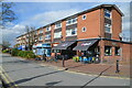
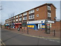
Parade of shops on Bodmin Avenue, Weeping Cross, Stafford
The shops were built in the 1960's and serve the Weeping Cross area. Similar parades are found around Stafford serving housing developments.
Image: © Rod Grealish
Taken: 4 Mar 2024
0.11 miles
2
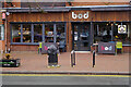
Bod at Weeping Cross
Buried deep in the Stafford suburbs, this Bod (on Bodmin Avenue - hence the name) was opened in 2018, the first of a chain of Bods operated by Titanic Brewery. It is a strange sort of hybrid between a coffee shop and a pub. The ambience is more Starbucks than Dog & Duck but there is a proper bar serving Titanic's range of ales and other alcoholic drinks. Interestingly, this shop unit was formerly a Co-op; the Co-op has moved across the road into a new building that replaced a pub. Perhaps Bod represents the future for pubs.
Image: © Stephen McKay
Taken: 5 Jan 2023
0.12 miles
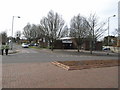
4
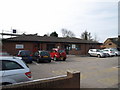
Baswich Community Library, Weeping Cross, Stafford
The library is a Community Managed Library run by a team of volunteers under the management of the Midlands Partnership NHS Foundation Trust. It is situated at the junction of Lynton Avenue and Bodmin Avenue
Image: © Rod Grealish
Taken: 4 Mar 2024
0.13 miles
5
Shops, Bodmin Avenue, Weeping Cross, Stafford
Image: © Tim Marshall
Taken: 16 Mar 2009
0.13 miles
6
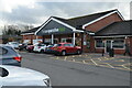
Co-operative food supermarket Lynton Avenue, Weeping Cross, Stafford
A food supermarket operated by Central England Co-operative Limited. The site was originally contained a public house known as The Crossbow opened in the 1960's and later renamed The Lynton Tavern. It was demolished in 2015 to make way for the supermarket.
Image: © Rod Grealish
Taken: 4 Mar 2024
0.15 miles
7
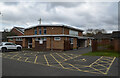
St Anne's Church Hall, Weeping Cross, Stafford
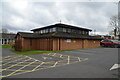
The parish of St Anne's was created in 1964. The church hall, shown here, was opened in 1966 as a dual-purpose church and hall. The present church was built in 1986-7 and the original building became the church hall.
Image: © Rod Grealish
Taken: 4 Mar 2024
0.16 miles
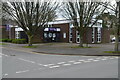
8
Weeping Cross Health Centre, Bodmin Avenue, Stafford
Image: © Tim Marshall
Taken: 16 Mar 2009
0.17 miles
9
St Anne's Catholic Church, Weeping Cross, Stafford
The parish of St Anne's was created in 1964. A dual-purpose church and hall opened in 1966. The present church was built in 1986-7 and the original building became the church hall.
Image: © Rod Grealish
Taken: 4 Mar 2024
0.18 miles
10
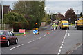
Resurfacing work on Baswich Lane
Just by the junction with Brendon Close.
Image: © Bill Boaden
Taken: 21 Oct 2011
0.18 miles