IMAGES TAKEN NEAR TO
Cornwall Drive, STAFFORD, ST17 0FT
Introduction
This page details the photographs taken nearby to Cornwall Drive, ST17 0FT by members of the Geograph project.
The Geograph project started in 2005 with the aim of publishing, organising and preserving representative images for every square kilometre of Great Britain, Ireland and the Isle of Man.

There are currently over 7.5m images from over14,400 individuals and you can help contribute to the project by visiting https://www.geograph.org.uk
Image Map (65 Images)


Getting Data...Please wait
Leaflet Map data © OpenStreetMap
Images are licensed for reuse under creativecommons.org/licenses/by-sa/2.0
Notes
- Clicking on the map will re-center to the selected point.
- The higher the marker number, the further away the image location is from the centre of the postcode.
Image Listing (65 Images Found)
Images are licensed for reuse under creativecommons.org/licenses/by-sa/2.0
Image
Details
Distance
1
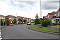
Cornwall Drive, Baswich
This area is a reasonably recent development.
Image: © Mick Malpass
Taken: 21 Jun 2011
0.01 miles
2
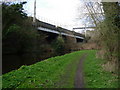
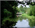
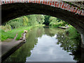
Railway viaduct and Staffs & Worcs Canal, Baswich, Staffordshire.
Image: © Tim Marshall
Taken: 31 Mar 2009
0.06 miles
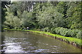
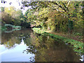
5
Staffordshire and Worcestershire Canal east of Stafford
This is approaching Lodgefield Bridge (No 102) near Baswich.
Image: © Roger D Kidd
Taken: 6 Sep 2009
0.09 miles
6
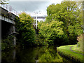
Canal and railway near Stafford
This is the Staffordshire and Worcestershire Canal, looking north-west near Weeping Cross. The west coast main line railway between Rugeley and Stafford is on the left.
Image: © Roger D Kidd
Taken: 6 Oct 2017
0.09 miles
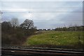
7
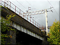
West Coast Main Line east of Stafford
The West Coast Main Line is adjacent to the Staffordshire and Worcestershire Canal here near Weeping Cross.
Image]
Image: © Roger D Kidd
Taken: 6 Oct 2017
0.09 miles
8
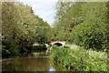
Canal near Weeping Cross in Staffordshire
On the Staffordshire and Worcestershire Canal, looking north-west towards Lodgefield Bridge, No 102. This former accommodation bridge appears to serve no purpose now since the development of the mobile home park past the bridge.
Image: © Roger Kidd
Taken: 22 May 2019
0.10 miles
9
Staffordshire and Worcestershire Canal east of Stafford
This is where the canal takes a long bend to the east as it skirts the higher land at Baswich and Weeping Cross. The bridge is No 102, Lodgefield Bridge.
Image: © Roger D Kidd
Taken: 29 Aug 2008
0.10 miles
10
Staffordshire and Worcestershire Canal near Baswich, Staffordshire
Image: © Roger D Kidd
Taken: 18 Oct 2007
0.10 miles