IMAGES TAKEN NEAR TO
Cornwall Drive, STAFFORD, ST17 0FG
Introduction
This page details the photographs taken nearby to Cornwall Drive, ST17 0FG by members of the Geograph project.
The Geograph project started in 2005 with the aim of publishing, organising and preserving representative images for every square kilometre of Great Britain, Ireland and the Isle of Man.

There are currently over 7.5m images from over14,400 individuals and you can help contribute to the project by visiting https://www.geograph.org.uk
Image Map (Loading...)


Getting Data...Please wait
Leaflet Map data © OpenStreetMap
Images are licensed for reuse under creativecommons.org/licenses/by-sa/2.0
Notes
- Clicking on the map will re-center to the selected point.
- The higher the marker number, the further away the image location is from the centre of the postcode.
Image Listing (58 Images Found)
Images are licensed for reuse under creativecommons.org/licenses/by-sa/2.0
Image
Details
Distance
1
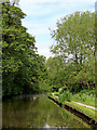
Canal approaching Stafford
This shows the Staffordshire and Worcestershire Canal east of Baswich. The canal by-passes Stafford town centre, but an old canal/river link is making slow but steady restoration progress about half a mile ahead.
Image: © Roger Kidd
Taken: 22 May 2019
0.12 miles
2
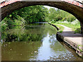
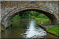
Canal near Weeping Cross in Staffordshire
This shows the Staffordshire and Worcestershire Canal, looking north-west towards Stafford, through the arch of Lodgefield Bridge, No 102.
Image: © Roger Kidd
Taken: 22 May 2019
0.12 miles
3
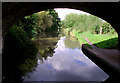
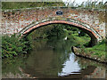
Staffordshire and Worcestershire Canal near Baswich, Stafford
Seen from beneath the arch of Lodgefield Bridge, No 102, looking north-west.
Image: © Roger D Kidd
Taken: 4 Sep 2011
0.12 miles
4
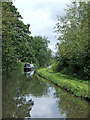
Canal near Weeping Cross in Stafford
Looking north-west as the Staffordshire and Worcestershire Canal meanders towards Stafford, Penkridge and Wolverhampton. Stoneford Bridge, No 103., is nearby behind the camera.
Image: © Roger Kidd
Taken: 6 Sep 2009
0.12 miles
5
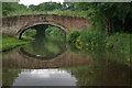
Lodgefield Bridge near Weeping Cross, Stafford
This shows Lodgefield Bridge, No 102 across the Staffordshire and Worcestershire Canal. The former accommodation bridge appears to serve no purpose now since the development of the mobile home park, off to the left beyond the bridge. Off to the right are pastures by the River Sow.
Image: © Roger Kidd
Taken: 1 Sep 2012
0.13 miles
6
Lodgefield Bridge, Staffs & Worcs Canal
Bridge 102, serving no obvious purpose in modern times, crosses the canal adjacent to the West Coast Main Line.
Image: © Stephen McKay
Taken: 24 Jun 2012
0.13 miles
7
Lodgefield Bridge, Staffordshire and Worcestershire Canal east of Stafford
This is Bridge No 102 counting from Stourport on Severn.
Image: © Roger D Kidd
Taken: 29 Aug 2008
0.13 miles
8
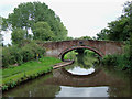
Canal at Lodgefield Bridge near Baswich, Stafford
Lodgefield Bridge is No 102 across the Staffordshire and Worcestershire Canal. It is a former accommodation bridge which has no public right of way across it.
The Way for the Millennium long distance path utilises the towpath here.
https://en.wikipedia.org/wiki/Way_for_the_Millennium
Image: © Roger Kidd
Taken: 6 Sep 2009
0.13 miles
9
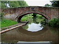
Lodgefield Bridge, Staffordshire and Worcestershire Canal east of Stafford
Bridges on this canal are numbered from No 1 at Stourport on Severn to No 109 at Great Haywood. In fact some have been removed and others built since the present numbers were attached, so I will need to physically count all the bridges in existence now to be sure of the actual number.
Image: © Roger D Kidd
Taken: 29 Aug 2008
0.13 miles
10
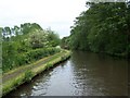
Approaching Lodgefield Bridge
On the Staffordshire and Worcestershire Canal
Image: © Geoff Pick
Taken: 25 May 2009
0.13 miles