IMAGES TAKEN NEAR TO
Sandringham Road, STAFFORD, ST17 0AA
Introduction
This page details the photographs taken nearby to Sandringham Road, ST17 0AA by members of the Geograph project.
The Geograph project started in 2005 with the aim of publishing, organising and preserving representative images for every square kilometre of Great Britain, Ireland and the Isle of Man.

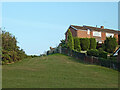
There are currently over 7.5m images from over14,400 individuals and you can help contribute to the project by visiting https://www.geograph.org.uk
Image Map
Images are licensed for reuse under creativecommons.org/licenses/by-sa/2.0
Notes
- Clicking on the map will re-center to the selected point.
- The higher the marker number, the further away the image location is from the centre of the postcode.
Image Listing (159 Images Found)
Images are licensed for reuse under creativecommons.org/licenses/by-sa/2.0
Image
Details
Distance
1
Osborne Crescent, Baswich Lane
Notice the solar panels on the two houses just off centre to the right.
Image: © Mick Malpass
Taken: 21 Jun 2011
0.03 miles
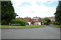
2
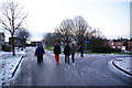
The junction of Sandringham Road and Osborne Crescent
The road surface was extremely icy.
Image: © Bill Boaden
Taken: 25 Dec 2009
0.03 miles
3
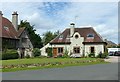
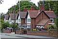
Shawms Cottage, Radford Rise, Weeping Cross
Clearly part of the same construction as the main house 'Shawms' to the left, although it is not included as part of the Listing of the house.
Image: © Alan Murray-Rust
Taken: 16 Aug 2017
0.08 miles
4
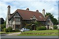
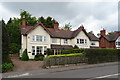
Shawms, Radford Rise, Weeping Cross
Classic Arts and Crafts style house in the Voysey tradition, by Henry T Sandy for HJ Bostock. Roughcast with sandstone dressings, dated 1905. Lg II. Now converted to flats.
Image: © Alan Murray-Rust
Taken: 16 Aug 2017
0.09 miles
5
Parkland and housing near Weeping Cross, Stafford
Looking east-south-east from near the canal, the pleasant public grassy area is by housing in Osborne Crescent.
Image: © Roger Kidd
Taken: 11 Sep 2014
0.10 miles
6
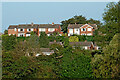
Housing at Weeping Cross in Stafford
A telephoto assisted image, looking east across meadows by the River Penk, and the Staffordshire and Worcestershire Canal (hidden by the trees). The houses on the skyline are in Sandringham Road. Lower down are houses in Meadow Ridge, by the canal.
Image: © Roger Kidd
Taken: 11 Sep 2014
0.10 miles
8
Radford Bank houses near Weeping Cross, Stafford
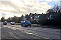
These houses are near the top of the A34 Radford Bank south-east of Stafford town centre.
Image: © Roger Kidd
Taken: 4 Aug 2015
0.12 miles
10
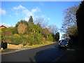
Radford Rise, Weeping Cross
A private residential road off Radford Bank (the A34) just west of Weeping Cross roundabout.
Image: © Richard Vince
Taken: 11 Jan 2014
0.12 miles