IMAGES TAKEN NEAR TO
Elgar Crescent, STOKE-ON-TRENT, ST1 6TG
Introduction
This page details the photographs taken nearby to Elgar Crescent, ST1 6TG by members of the Geograph project.
The Geograph project started in 2005 with the aim of publishing, organising and preserving representative images for every square kilometre of Great Britain, Ireland and the Isle of Man.

There are currently over 7.5m images from over14,400 individuals and you can help contribute to the project by visiting https://www.geograph.org.uk
Image Map (Loading...)


Getting Data...Please wait
Leaflet Map data © OpenStreetMap
Images are licensed for reuse under creativecommons.org/licenses/by-sa/2.0
Notes
- Clicking on the map will re-center to the selected point.
- The higher the marker number, the further away the image location is from the centre of the postcode.
Image Listing (46 Images Found)
Images are licensed for reuse under creativecommons.org/licenses/by-sa/2.0
Image
Details
Distance
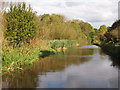
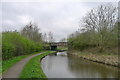
2
Caldon Canal south-east of Birches Head, Stoke-on-Trent
Looking north-east as the Caldon Canal meanders towards Stockton Brook, Endon, Cheddleton and Froghall.
Image: © Roger Kidd
Taken: 12 Sep 2019
0.06 miles
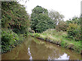
3

Caldon Canal near Birches Head, Stoke-on-Trent
Looking south-west as the canal meanders towards Hanley and Etruria Junction.
Image: © Roger Kidd
Taken: 2 Aug 2015
0.06 miles
4
Caldon Canal south-east of Birches Head, Stoke-on-Trent
Looking north-east as the Caldon Canal meanders towards Stockton Brook, Endon, Cheddleton and Froghall.
Image: © Roger Kidd
Taken: 12 Sep 2019
0.06 miles
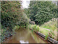
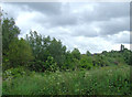
5
Caldon Canal east of Birches Head, Stoke-on-Trent
Image: © Roger Kidd
Taken: 12 Sep 2019
0.09 miles
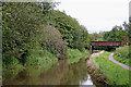
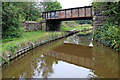
6
Mill Farm Railway Bridge no. 14A
Carrying the 'mothballed' Stoke-on-Trent to Leek line. Parts of the line may be re-opened https://tinyurl.com/y66k78ab
Image: © Tim Heaton
Taken: 18 Apr 2018
0.10 miles
7
Course of disused railway near Bucknall, Stoke-on-Trent
Seen from a narrowboat on the canal, this line, opened in 1849 and closed in 1988, still has the track in place on the embankment among the trees and other undergrowth. Re-opening soon from Stoke to Leek, and also Cauldon Low Quarry, is planned by the newly formed Moorland and City Railways Co. The eight mile section to the quarry is already in use.
Image: © Roger D Kidd
Taken: 27 May 2011
0.10 miles
8
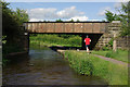
Bridge 14A, Caldon Canal
A jogger heads along the towpath under the railway bridge in late afternoon sunshine. The railway above is disused.
Image: © Stephen McKay
Taken: 27 Jun 2012
0.11 miles
9
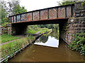
Railway Bridge north of Bucknall, Stoke-on-Trent
This is bridge No 14A across the Caldon Canal, looking towards Hanley and Stoke-on-Trent.
Bridge No 14A carries a disused railway line, possibly to be re-opened if the Moorland and City Railways Co succeed in their plans. It was part of the North Staffordshire Railway from Stoke towards Congleton, with a branch to Cauldon Low quarry.
Image: © Roger Kidd
Taken: 15 Sep 2019
0.11 miles
10
Railway Bridge north of Bucknall, Stoke-on-Trent
This is bridge No 14A across the Caldon Canal, looking southwest towards Hanley and Stoke-on-Trent.
Bridge No 14A carries a disused railway line, possibly to be re-opened if the Moorland and City Railways Co succeed in their plans. It was part of the North Staffordshire Railway from Stoke towards Congleton, with a branch to Cauldon Low quarry.
Image: © Roger Kidd
Taken: 15 Sep 2019
0.11 miles