IMAGES TAKEN NEAR TO
Danebridge Grove, STOKE-ON-TRENT, ST1 6SA
Introduction
This page details the photographs taken nearby to Danebridge Grove, ST1 6SA by members of the Geograph project.
The Geograph project started in 2005 with the aim of publishing, organising and preserving representative images for every square kilometre of Great Britain, Ireland and the Isle of Man.

There are currently over 7.5m images from over14,400 individuals and you can help contribute to the project by visiting https://www.geograph.org.uk
Image Map (Loading...)


Getting Data...Please wait
Leaflet Map data © OpenStreetMap
Images are licensed for reuse under creativecommons.org/licenses/by-sa/2.0
Notes
- Clicking on the map will re-center to the selected point.
- The higher the marker number, the further away the image location is from the centre of the postcode.
Image Listing (33 Images Found)
Images are licensed for reuse under creativecommons.org/licenses/by-sa/2.0
Image
Details
Distance
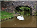
1
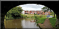
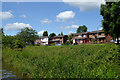
Caldon Canal near Birches Head, Stoke-on-Trent
The Caldon Canal is seen through the arch of Botany Bay Bridge (No 14). The housing is in Monsal Grove, at the southern end of Birches Head.
Image: © Roger Kidd
Taken: 12 Sep 2019
0.12 miles
2
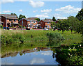
Canalside housing near Northwood, Stoke-on-Trent
The houses are in Monsal Grove by the Caldon Canal.
Image: © Roger D Kidd
Taken: 31 Jul 2015
0.12 miles
3
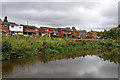
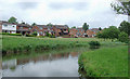
Canal and housing near Birches Head, Stoke-on-Trent
At the southern end of the Birches Head housing area in Stoke-on-Trent, and by the Caldon Canal, these houses are in Monsal Grove.
Image: © Roger Kidd
Taken: 12 Sep 2019
0.13 miles
4
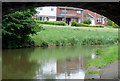
Canal and housing near Northwood, Stoke-on-Trent
Housing in Monsal Grove seen from beneath Bridge No 14 on the Caldon Canal.
Image: © Roger D Kidd
Taken: 27 May 2011
0.13 miles
5
Canalside housing near Northwood, Stoke-on-Trent
The houses are in Monsal Grove by the Caldon Canal.
Image: © Roger D Kidd
Taken: 31 Jul 2015
0.14 miles
6
Canal and housing near Northwood, Stoke-on-Trent
Housing in Monsal Grove by the Caldon Canal.
The Caldon Branch of the Trent and Mersey Canal opened in 1779. It runs eighteen miles from Etruria in Stoke-on-Trent, where it leaves the Trent and Mersey Canal. It terminates at Froghall about five miles south-east of Cheddleton. The canal has seventeen locks and the 69 metre long very low Froghall Tunnel, unusable by many narrowboats. The canal did originally continue through to Uttoxeter, but the section beyond Froghall was closed by the late 1840s, much of its course being filled in to construct a railway.
Image: © Roger D Kidd
Taken: 27 May 2011
0.15 miles
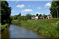
7
Canal and Bridge No 14 near Northwood, Stoke-on-Trent
The Caldon Canal meanders a lot as it follows its contour along the Trent Valley through Stoke. Here, Bridge No 14 gives access to open woodland and heathland by the river to the right, and the canal swings to the east past housing in Monsal Grove.
Image: © Roger D Kidd
Taken: 27 May 2011
0.15 miles
8
Caldon canal near Northwood, Stoke-on-Trent
The houses are in Monsal Grove by the Caldon Canal.
Image: © Roger D Kidd
Taken: 31 Jul 2015
0.15 miles
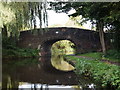
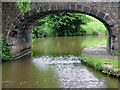
10
Botany Bay Bridge north-east of Hanley, Stoke-on-Trent
Botany Bay Bridge is No 14 across the Caldon Canal near Bucknall. It was originally a farm accommodation bridge, but now, with housing to the north and industrial units to the south-east, it is just a footbridge open to the public.
Image: © Roger Kidd
Taken: 15 Sep 2019
0.15 miles