IMAGES TAKEN NEAR TO
Huntingdon Place, STOKE-ON-TRENT, ST1 6RX
Introduction
This page details the photographs taken nearby to Huntingdon Place, ST1 6RX by members of the Geograph project.
The Geograph project started in 2005 with the aim of publishing, organising and preserving representative images for every square kilometre of Great Britain, Ireland and the Isle of Man.

There are currently over 7.5m images from over14,400 individuals and you can help contribute to the project by visiting https://www.geograph.org.uk
Image Map (Loading...)


Getting Data...Please wait
Leaflet Map data © OpenStreetMap
Images are licensed for reuse under creativecommons.org/licenses/by-sa/2.0
Notes
- Clicking on the map will re-center to the selected point.
- The higher the marker number, the further away the image location is from the centre of the postcode.
Image Listing (10 Images Found)
Images are licensed for reuse under creativecommons.org/licenses/by-sa/2.0
Image
Details
Distance
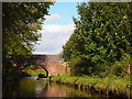
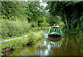
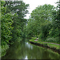
2
Caldon Canal south of Milton, Stoke-on-Trent
Looking north-west towards Birches Head Road Bridge, No 15.
Image: © Roger D Kidd
Taken: 27 May 2011
0.23 miles
3
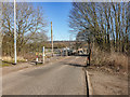
Disused Railway Crossing
The Stoke–Leek line was opened by the North Staffordshire Railway (NSR) in 1867. Milton and Endon were the original stations on the line that opened at the same time as the line. Situated on the single track section of the line between Milton Junction (where the line diverged from the Biddulph Valley line) and Endon, the station had only a single platform.
Passenger services over the line were withdrawn in 1956 and the station closed. The line through the station continued in use until 1988 for freight services and since 1988 the line has officially been out of use but not closed.
https://en.wikipedia.org/wiki/Stoke%E2%80%93Leek_line
Image: © Brian Deegan
Taken: 26 Feb 2019
0.23 miles
4
Caldon Canal north-east of Hanley, Stoke-on-Trent
Image: © Roger D Kidd
Taken: 2 Aug 2015
0.24 miles
5
Caldon Canal north-east of Hanley, Stoke-on-Trent
Image: © Roger D Kidd
Taken: 2 Aug 2015
0.24 miles
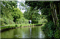
6
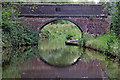
Birches Head Road Bridge north-east of Stoke-on-Trent
Birches Head Road Bridge is No 15 across the Caldon Canal near Abbey Hulton. This bridge has retained its number in the masonry.
Looking north-north-west as the Caldon Canal meanders towards Milton, Stockton Brook, Endon, Cheddleton and Froghall.
Image: © Roger Kidd
Taken: 12 Sep 2019
0.24 miles
7
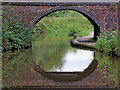
Birches Head Road Bridge north-east of Stoke-on-Trent
Birches Head Road Bridge is No 15 across the Caldon Canal near Abbey Hulton. This bridge has retained its number in the masonry. A separate footbridge is in place beyond the old stone structure because an adjacent school needs to have greater safety measures in place.
Looking north-north-west as the Caldon Canal meanders towards Milton, Stockton Brook, Endon, Cheddleton and Froghall.
Image: © Roger Kidd
Taken: 12 Sep 2019
0.24 miles
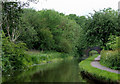
8
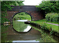
Bridge No 15 south of Milton, Stoke-on-Trent
The Caldon branch of the Trent and Mersey Canal.
The bridge carries Birches Head Road. The bridge number can be seen on the bridge stone work above the arch.
Image: © Roger D Kidd
Taken: 27 May 2011
0.24 miles
9
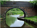
Bridge No 15 south of Milton, Stoke-on-Trent
The Caldon branch of the Trent and Mersey Canal.
The bridge carries Birches Head Road. The bridge number can be seen on the bridge stone work above the arch.
Image: © Roger D Kidd
Taken: 27 May 2011
0.24 miles
10
Caldon Canal south of Milton, Stoke-on-Trent
The River Trent meanders northwards through scrub and grass land about fifty metres off to the right.
The Caldon Branch of the Trent and Mersey Canal opened in 1779. It runs eighteen miles from Etruria in Stoke-on-Trent, where it leaves the Trent and Mersey Canal. It terminates at Froghall about five miles south-east of Cheddleton. The canal has seventeen locks and the 69 metre long very low Froghall Tunnel, unusable by many narrowboats. The canal did originally continue through to Uttoxeter, but the section beyond Froghall was closed by the late 1840s, much of its course being filled in to construct a railway.
Image: © Roger D Kidd
Taken: 27 May 2011
0.24 miles