IMAGES TAKEN NEAR TO
Leek Road, STOKE-ON-TRENT, ST1 6AQ
Introduction
This page details the photographs taken nearby to Leek Road, ST1 6AQ by members of the Geograph project.
The Geograph project started in 2005 with the aim of publishing, organising and preserving representative images for every square kilometre of Great Britain, Ireland and the Isle of Man.

There are currently over 7.5m images from over14,400 individuals and you can help contribute to the project by visiting https://www.geograph.org.uk
Image Map
Images are licensed for reuse under creativecommons.org/licenses/by-sa/2.0
Notes
- Clicking on the map will re-center to the selected point.
- The higher the marker number, the further away the image location is from the centre of the postcode.
Image Listing (29 Images Found)
Images are licensed for reuse under creativecommons.org/licenses/by-sa/2.0
Image
Details
Distance
1
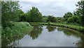
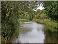
Caldon Canal near Northwood, Stoke-on-Trent
Off to the left (north) is a housing estate reaching Birches Head. To the right is woodland (access by way of Bridge No 14 http://www.geograph.org.uk/photo/2483447 ) and open heath sloping down to the River Trent.
Image: © Roger D Kidd
Taken: 27 May 2011
0.08 miles
2
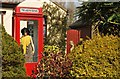
Who's That Girl?
You don't see this every day!
Image: © Stu JP
Taken: 8 Apr 2015
0.10 miles
3
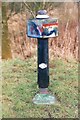
Old milemarker by the Caldon Canal, Northwood
Milemarker by the Caldon Canal, in parish of Stoke on Trent (Stoke on Trent District), Northeast of Northwood.
Inscription reads:-
: ETRURIA / 3 / MILES : : UTTOXETER / 27 / MILES :
Maker:-
: C / 19 81 / CS :
(Caldon Canal Society)
Surveyed
Milestone Society National ID: CAL-03R
Image: © Milestone Society
Taken: Unknown
0.13 miles
4
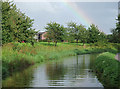
The Caldon Canal near Northwood, Stoke-on-Trent
An attractively landscaped grass area fronts the recent housing of Monsal Grove.
Image: © Roger D Kidd
Taken: 1 Sep 2009
0.13 miles
5
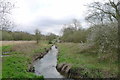
The River Trent between Northwood and Abbey Hulton, Stoke-On-Trent
Deviating off the canal towpath to see my old friend again. This is my last leg of completing the Trent Valley Way.
Image: © Tim Heaton
Taken: 18 Apr 2018
0.13 miles
6
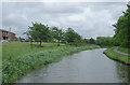
Caldon Canal near Northwood, Stoke-on-Trent
To the left (north) is a housing estate reaching Birches Head. To the right is woodland (access by way of Bridge No 14 http://www.geograph.org.uk/photo/2483447 ) and open heath down to the River Trent.
The Caldon Branch of the Trent and Mersey Canal opened in 1779. It runs eighteen miles from Etruria in Stoke-on-Trent, where it leaves the Trent and Mersey Canal. It terminates at Froghall about five miles south-east of Cheddleton. The canal has seventeen locks and the 69 metre long very low Froghall Tunnel, unusable by many narrowboats. The canal did originally continue through to Uttoxeter, but the section beyond Froghall was closed by the late 1840s, much of its course being filled in to construct a railway.
Image: © Roger D Kidd
Taken: 27 May 2011
0.14 miles
7
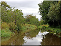
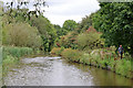
Caldon Canal south of Birches Head, Stoke-on-Trent
This is the Caldon Canal, looking east as it meanders towards Stockton Brook, Endon, Cheddleton and Froghall.
Image: © Roger Kidd
Taken: 12 Sep 2019
0.14 miles
8
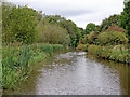
Caldon Canal near Birches Head, Stoke-on-Trent
This is the Caldon Canal south-east of Birches Head, looking north-north-east as it meanders towards Stockton Brook, Endon, Cheddleton and Froghall. There is a winding hole about forty metres ahead on the left, by those reeds.
Image: © Roger Kidd
Taken: 12 Sep 2019
0.15 miles
9
Caldon Canal near Birches Head, Stoke-on-Trent
This is the Caldon Canal south-east of Birches Head, looking north-north-east as it meanders towards Stockton Brook, Endon, Cheddleton and Froghall.
Image: © Roger Kidd
Taken: 12 Sep 2019
0.16 miles
10
Caldon Canal near Birches Head, Stoke-on-Trent
This is the Caldon Canal south-east of Birches Head, looking north-north-east as it meanders towards Stockton Brook, Endon, Cheddleton and Froghall. There is a winding hole about fifty metres ahead on the left, by those reeds.
Image: © Roger Kidd
Taken: 12 Sep 2019
0.16 miles