IMAGES TAKEN NEAR TO
Beaconside, STAFFORD, ST16 3ZB
Introduction
This page details the photographs taken nearby to Beaconside, ST16 3ZB by members of the Geograph project.
The Geograph project started in 2005 with the aim of publishing, organising and preserving representative images for every square kilometre of Great Britain, Ireland and the Isle of Man.

There are currently over 7.5m images from over14,400 individuals and you can help contribute to the project by visiting https://www.geograph.org.uk
Image Map (Loading...)


Getting Data...Please wait
Leaflet Map data © OpenStreetMap
Images are licensed for reuse under creativecommons.org/licenses/by-sa/2.0
Notes
- Clicking on the map will re-center to the selected point.
- The higher the marker number, the further away the image location is from the centre of the postcode.
Image Listing (4 Images Found)
Images are licensed for reuse under creativecommons.org/licenses/by-sa/2.0
Image
Details
Distance

3
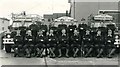
RAF Stafford Mountain Rescue Team 1984
Team photograph of the RAF Stafford Mountain Rescue Team in 1984.
Image: © steve evans
Taken: 5 Jul 1984
0.12 miles
4
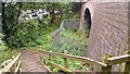
Stairs to the disused railway, Stafford
The railway route has been converted into a foot/cycle way, connecting the A513 to the centre of Stafford.
Image: © Oliver Mills
Taken: 14 Jul 2020
0.18 miles