
IMAGES TAKEN NEAR TO
St. Georges Parkway, STAFFORD, ST16 3YZ
Introduction
This page details the photographs taken nearby to St. Georges Parkway, ST16 3YZ by members of the Geograph project.
The Geograph project started in 2005 with the aim of publishing, organising and preserving representative images for every square kilometre of Great Britain, Ireland and the Isle of Man.

There are currently over 7.5m images from over14,400 individuals and you can help contribute to the project by visiting https://www.geograph.org.uk
Image Map
Images are licensed for reuse under creativecommons.org/licenses/by-sa/2.0
Notes
- Clicking on the map will re-center to the selected point.
- The higher the marker number, the further away the image location is from the centre of the postcode.
Image Listing (107 Images Found)
Images are licensed for reuse under creativecommons.org/licenses/by-sa/2.0
Image
Details
Distance
1
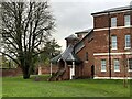
External stairs at St George's Mansions
Image: © Jonathan Hutchins
Taken: 22 Nov 2022
0.02 miles
2
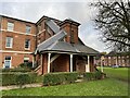
Outside staircases at former St George's Hospital
The main building, of which this is the eastern end, is Grade II listed, see https://historicengland.org.uk/listing/the-list/list-entry/1195385
Image: © Jonathan Hutchins
Taken: 22 Nov 2022
0.02 miles
3
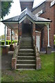
Gated Stairway at south-east end of St George's Mansion
The stairway is at the south-east end 0f St George's Mansion. It gives external access to the floors of the Mansion but appears not to have been used for some time. It lacks any fire safety features.
Image: © Rod Grealish
Taken: 21 Jun 2024
0.03 miles
4

St Georges Asylum
The old Asylum next door to the prison
Image: © Markb03
Taken: 19 Apr 2008
0.03 miles
5
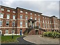
St George's Mansions
The main original St George's hospital building of 1818, converted into apartments.
It is Grade II listed, see https://historicengland.org.uk/listing/the-list/list-entry/1195385
A Geograph image of the building before its restoration is Image while a fine set of photos taken before and during restoration is on the County Asylums website at https://www.countyasylums.co.uk/st-georges-stafford-staffordshire/
Image: © Jonathan Hutchins
Taken: 22 Nov 2022
0.03 miles
6

Site plan for St George's Mansions
This housing development consists in part of conversions of the nineteenth-century St George's Hospital buildings.
Image: © Jonathan Hutchins
Taken: 18 Nov 2022
0.03 miles
7
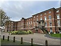
St George's Mansions
The main original St George's hospital building of 1818, converted into apartments.
It is Grade II listed, see https://historicengland.org.uk/listing/the-list/list-entry/1195385
A Geograph image of the building before its restoration is Image while a fine set of photos taken before and during restoration is on the County Asylums website at https://www.countyasylums.co.uk/st-georges-stafford-staffordshire/
Image: © Jonathan Hutchins
Taken: 22 Nov 2022
0.04 miles
8
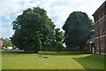
Lawn and Trees at south-east end of St George's Mansion
The trees and lawn formed part of the extensive grounds of the former St George's Hospital. The grounds have been extensively redeveloped with new housing but areas like this still exist in the hospital grounds.
Image: © Rod Grealish
Taken: 21 Jun 2024
0.04 miles
9
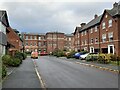
St George's Parkway development
To right and left are new builds, while in the background is the back of the east wing of the original Stafford General Asylum, converted to apartments.
Image: © Jonathan Hutchins
Taken: 22 Nov 2022
0.04 miles
10
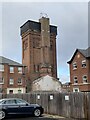
Water tower of the former St George's Hospital, Stafford
The original buildings, including the water tower, are grade II listed, see https://historicengland.org.uk/listing/the-list/list-entry/1195385
Image: © Jonathan Hutchins
Taken: 18 Nov 2022
0.04 miles