IMAGES TAKEN NEAR TO
St. Georges Parkway, STAFFORD, ST16 3WT
Introduction
This page details the photographs taken nearby to St. Georges Parkway, ST16 3WT by members of the Geograph project.
The Geograph project started in 2005 with the aim of publishing, organising and preserving representative images for every square kilometre of Great Britain, Ireland and the Isle of Man.

There are currently over 7.5m images from over14,400 individuals and you can help contribute to the project by visiting https://www.geograph.org.uk
Image Map
Images are licensed for reuse under creativecommons.org/licenses/by-sa/2.0
Notes
- Clicking on the map will re-center to the selected point.
- The higher the marker number, the further away the image location is from the centre of the postcode.
Image Listing (123 Images Found)
Images are licensed for reuse under creativecommons.org/licenses/by-sa/2.0
Image
Details
Distance
2
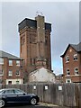
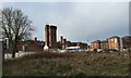
Water tower of the former St George's Hospital, Stafford
The original buildings, including the water tower, are grade II listed, see https://historicengland.org.uk/listing/the-list/list-entry/1195385
Image: © Jonathan Hutchins
Taken: 18 Nov 2022
0.05 miles
3
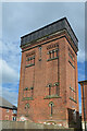
Disused Water Tower in grounds of former St George's Hospital, Stafford
St George's Hospital was closed in 1995 and converted to luxury apartments in 2018 with the name St George's Mansions. The water tower supplied water to the hospital. It has planning approval for conversion to a three-bedroom house over four floors with no change to the facade. The tower is grade II listed as part of the listing of St George's Hospital/Mansions.
Image: © Rod Grealish
Taken: 21 Jun 2024
0.05 miles
4
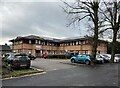
The Bridge, St George's Hospital
The Bridge is the base for the hospital Trust's Child and Adolescent Mental Health Services (CAMHS), which until about 2018 were formerly based only a hundred or so yards away in Swiftbrook House, now demolished - see Image
Image: © Jonathan Hutchins
Taken: 22 Nov 2022
0.05 miles
5
St George's Hospital, Stafford: old and new
Construction site, with the old asylum on the left (the water tower is a listed building) and new housing on the right.
Image: © Jonathan Hutchins
Taken: 13 Jan 2015
0.05 miles
6
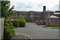
Former mental hospital converted to apartments
Now designated St George's Mansions, and grade II listed, see https://historicengland.org.uk/listing/the-list/list-entry/1195385
Image: © Jonathan Hutchins
Taken: 22 Nov 2022
0.05 miles
7
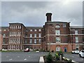
Rear view of former Stafford General Asylum
Stafford General Asylum opened in October 1818. Additional buildings behind the 1818 building were added in 1850, 1879 and 1884. The architect of the original building of 1818 was Joseph Potter. The hospital became Stafford Mental Hospital in the 1920s and was renamed St George's Hospital in 1948 at the start of the NHS.
The main building was closed in 1995 due to changes in the way patients were treated and it was converted into luxury apartments as St George's Mansions in 2018. The building is grade II listed.
Image: © Rod Grealish
Taken: 21 Jun 2024
0.05 miles

9
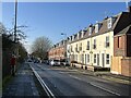
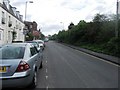
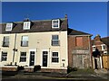
Crooked Bridge Road
The cream-coloured houses on the right are collectively named Westbourne Villas.
This stretch of Crooked Bridge Road is on the route of the Two Saints Way.
Image: © Jonathan Hutchins
Taken: 25 Nov 2022
0.06 miles
10
Municipal Cottages
This is the east end of Westbourne Villas, seen in Image
The inscription on the wall says
MUNICIPAL COTTAGES
ERECTED 1902.
Image: © Jonathan Hutchins
Taken: 25 Nov 2022
0.06 miles