IMAGES TAKEN NEAR TO
Tixall Road, STAFFORD, ST16 3UB
Introduction
This page details the photographs taken nearby to Tixall Road, ST16 3UB by members of the Geograph project.
The Geograph project started in 2005 with the aim of publishing, organising and preserving representative images for every square kilometre of Great Britain, Ireland and the Isle of Man.

There are currently over 7.5m images from over14,400 individuals and you can help contribute to the project by visiting https://www.geograph.org.uk
Image Map (Loading...)


Getting Data...Please wait
Leaflet Map data © OpenStreetMap
Images are licensed for reuse under creativecommons.org/licenses/by-sa/2.0
Notes
- Clicking on the map will re-center to the selected point.
- The higher the marker number, the further away the image location is from the centre of the postcode.
Image Listing (20 Images Found)
Images are licensed for reuse under creativecommons.org/licenses/by-sa/2.0
Image
Details
Distance
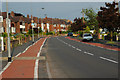
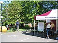
2

Cycle lanes as they should NOT be
Before you ask, yes I am making a point. Although these cars seem to be parked legally they make the existence of cycles lanes pointless (another waste of Council Tax payers money). I was almost knocked off my bike whilst passing cars parked in this stretch of cycle lane - not passing these two may I add. Perhaps you get my point. Pedestrians, cyclists & horse riders have a right to use the road, motorists only have a licence to do so! Personally I would prefer to keep the cycle lanes but would also like to see them used in the proper manner.
Image: © Row17
Taken: 2 Jun 2009
0.08 miles
3
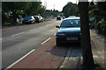
Since when have cycle lanes & pavements been car-parks?
Image: © Row17
Taken: 2 Jun 2009
0.13 miles
4
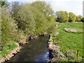
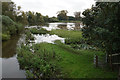
River Sow
The River Sow, looking downstream from Fairway Bridge.
Image: © David Dixon
Taken: 12 Apr 2011
0.17 miles
5
River Sow from Fairway bridge, looking east
The path alongside the river is part of the Two Saints Way.
Image: © Alan Murray-Rust
Taken: 16 Aug 2017
0.20 miles
6
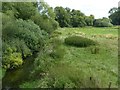
Scrapes, Stafford
Scrapes were being formed in this riverside meadow to attract birds. The River Sow is behind the camera. A item on local TV news, 11 September 2024, reported that Staffordshire Wildlife Trust and others are establishing a wildflower meadow here. Stafford Brook was a name mentioned.
Photo number 7857021.
Image: © Robin Stott
Taken: 14 Aug 2024
0.20 miles
7
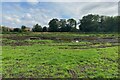
Way for the Millennium
It is not possible use this path due to flooding from the nearby River Sow.
Image: © Bill Boaden
Taken: 5 Oct 2019
0.20 miles
8
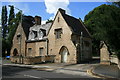
Weston Road Stafford
Thought to be the Lodge at the entrance to the former Cottonhill Asylum at Stafford.
Image: © David Rogers
Taken: 14 Aug 2008
0.21 miles
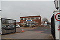
9
Katherine House Hospice
Hospice in Stafford, preparing for charity bike ride.
Image: © John Nickolls
Taken: 15 May 2005
0.21 miles