IMAGES TAKEN NEAR TO
Salisbury Road, STAFFORD, ST16 3SE
Introduction
This page details the photographs taken nearby to Salisbury Road, ST16 3SE by members of the Geograph project.
The Geograph project started in 2005 with the aim of publishing, organising and preserving representative images for every square kilometre of Great Britain, Ireland and the Isle of Man.

There are currently over 7.5m images from over14,400 individuals and you can help contribute to the project by visiting https://www.geograph.org.uk
Image Map (Loading...)


Getting Data...Please wait
Leaflet Map data © OpenStreetMap
Images are licensed for reuse under creativecommons.org/licenses/by-sa/2.0
Notes
- Clicking on the map will re-center to the selected point.
- The higher the marker number, the further away the image location is from the centre of the postcode.
Image Listing (12 Images Found)
Images are licensed for reuse under creativecommons.org/licenses/by-sa/2.0
Image
Details
Distance
2
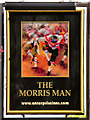
The Morris Man
The Morris Man public house, viewed from Allis Close.
Image: © David Dixon
Taken: 12 Apr 2011
0.17 miles
3
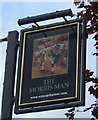
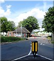
Sign for the Morris Man, Kingston Hill, Stafford
Image: © JThomas
Taken: 7 Oct 2017
0.17 miles

5
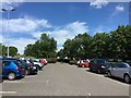
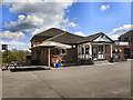
County Hospital, Stafford: car park C
Image: © Jonathan Hutchins
Taken: 24 Jun 2015
0.18 miles
6
Salmond Avenue, Stafford
The area used to be housing for RAF staff but is largely sold off to private occupiers or Health Service staff.
Image: © Stephen Pearce
Taken: 23 Oct 2006
0.22 miles
7
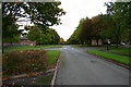
Beaconside looking towards the A518, Stafford
Beaconside looking towards the A518, Stafford. In the distance can be seen the new Stafford Technology park, a very large development bringing lots of businesses and jobs to Stafford.
Image: © Stephen Pearce
Taken: 23 Oct 2006
0.22 miles
9
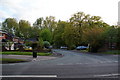
Sheringham Covert, Stafford
A residential enclave off the eastern ring road.
Image: © Bill Boaden
Taken: 15 May 2010
0.23 miles
10
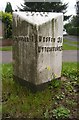
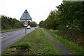
Old Milepost by the A518, Weston Road, Kingston Hill
Cast iron post by the A518, in parish of Stafford (Stafford District), Kingston Hill, on grass, on South side of road. Lathe iron casting, erected by the County Council in the 19th/20th century.
Inscription reads:-
: STAFFORD 1 : : HOPTON / AND / COTON : : WESTON 3¾ / UTTOXETER 13 :
Maker:-
: Chas. Lathe, Tipton. :
Staffordshire HER.
HER Number: 51809 https://www.heritagegateway.org.uk/Gateway/Results_Single.aspx?uid=MST13227&resourceID=1010
Milestone Society National ID: ST_STUT01
Image: © J Higgins
Taken: 1 Jan 2000
0.24 miles