IMAGES TAKEN NEAR TO
Newton Road, STAFFORD, ST16 3PN
Introduction
This page details the photographs taken nearby to Newton Road, ST16 3PN by members of the Geograph project.
The Geograph project started in 2005 with the aim of publishing, organising and preserving representative images for every square kilometre of Great Britain, Ireland and the Isle of Man.

There are currently over 7.5m images from over14,400 individuals and you can help contribute to the project by visiting https://www.geograph.org.uk
Image Map (Loading...)


Getting Data...Please wait
Leaflet Map data © OpenStreetMap
Images are licensed for reuse under creativecommons.org/licenses/by-sa/2.0
Notes
- Clicking on the map will re-center to the selected point.
- The higher the marker number, the further away the image location is from the centre of the postcode.
Image Listing (5 Images Found)
Images are licensed for reuse under creativecommons.org/licenses/by-sa/2.0
Image
Details
Distance
4

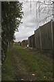
Gates to Coton Fields Allotments
This is the north-western end of the track, giving onto Prospect Road. The track is accessible to gardeners' vehicles but users are urged to CLOSE LOCK AND SCRAMBLE [i.e. the lock combination] in order to deter trespass and vandalism. On the left is the pedestrian entrance. The track is a public footpath designated Stafford 7 and is part of the Two Saints Way.
Image: © Jonathan Hutchins
Taken: 11 Nov 2022
0.24 miles