IMAGES TAKEN NEAR TO
Gaol Road, STAFFORD, ST16 3AN
Introduction
This page details the photographs taken nearby to Gaol Road, ST16 3AN by members of the Geograph project.
The Geograph project started in 2005 with the aim of publishing, organising and preserving representative images for every square kilometre of Great Britain, Ireland and the Isle of Man.

There are currently over 7.5m images from over14,400 individuals and you can help contribute to the project by visiting https://www.geograph.org.uk
Image Map
Images are licensed for reuse under creativecommons.org/licenses/by-sa/2.0
Notes
- Clicking on the map will re-center to the selected point.
- The higher the marker number, the further away the image location is from the centre of the postcode.
Image Listing (165 Images Found)
Images are licensed for reuse under creativecommons.org/licenses/by-sa/2.0
Image
Details
Distance
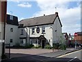
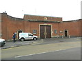
1
Stafford Prison
Stafford Prison on Gaol Road
Image: © Stephen Pearce
Taken: 13 Nov 2006
0.01 miles
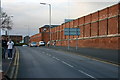
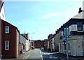
2
Looking north up Gaol Road
The gable wall on the other side of the road has a rather good example of a ghost sign advertisement. The words "Wills's Gold Flake Cigarettes" are obviously most prominent, but the older wording at the top also has the words "tobacco" and "tobacconists" in it, which suggests there may have been such a business in the premises for quite a while some years ago.
Image: © Richard Law
Taken: 4 Nov 2020
0.02 miles
3

Western perimeter wall of Stafford Prison - Gaol Road
The rather impressive western perimeter wall of the prison, which were built in the 1790s, altered in the 1950s (turrets in a number of angles were demolished) and Grade II listed https://britishlistedbuildings.co.uk/101211998-perimeter-walls-to-west-and-north-of-hm-prison-stafford-coton-ward#.YaQD9NDP3IU & https://historicengland.org.uk/listing/the-list/list-entry/1211998 in 1971.
Image: © Richard Law
Taken: 4 Nov 2020
0.02 miles
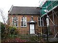
4
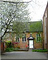
Friends' Meeting House
The Friends' Meeting House [Quakers]in Stafford dates from 1730 and is still in use.
Image: © Simon Huguet
Taken: 29 Apr 2008
0.03 miles
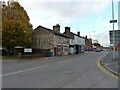
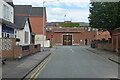
5
County Road, Stafford
Looking from Foregate along County Street towards the main gate of Stafford Prison.
Image: © Simon Huguet
Taken: 26 Jul 2008
0.04 miles
6
The Quaker Friends' Meeting House on Foregate Street
This small Meeting house dates from 1730, and was Grade II* listed https://britishlistedbuildings.co.uk/101211911-friends-meeting-house-stafford-coton-ward#.YZPz-GDP3IU & https://historicengland.org.uk/listing/the-list/list-entry/1211911 in 1951. It retains many of its original interior features, and is described as "Well preserved...best in Staffordshire" in the listing.
Image: © Richard Law
Taken: 4 Nov 2020
0.04 miles
8
Main entrance to Stafford Prison
The main entrance to Stafford Prison, officially known as HM Prison Stafford, is on Gaol Street. The prison is classed as a Category 'C' Prison facility for male adults. The image was taken from County Road. The oldest part of the prison was built 1787–93. This part and several other parts of the prison are grade II listed. Former 'residents' include William Palmer, physician and poisoner, executed and buried at the prison, Michael Collins, Irish revolutionary leader, and Rolf Harris, TV entertainer.
Image: © Rod Grealish
Taken: 21 Jun 2024
0.05 miles
9
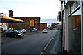
Gaol Road, Stafford
Gaol Road looking south towards Stafford town centre, Crooked Bridge Road is off to the left beyond the petrol station with Stafford Prison dominating the area.
Image: © Stephen Pearce
Taken: 13 Nov 2006
0.05 miles