
IMAGES TAKEN NEAR TO
Gaol Road, STAFFORD, ST16 3AJ
Introduction
This page details the photographs taken nearby to Gaol Road, ST16 3AJ by members of the Geograph project.
The Geograph project started in 2005 with the aim of publishing, organising and preserving representative images for every square kilometre of Great Britain, Ireland and the Isle of Man.

There are currently over 7.5m images from over14,400 individuals and you can help contribute to the project by visiting https://www.geograph.org.uk
Image Map
Images are licensed for reuse under creativecommons.org/licenses/by-sa/2.0
Notes
- Clicking on the map will re-center to the selected point.
- The higher the marker number, the further away the image location is from the centre of the postcode.
Image Listing (229 Images Found)
Images are licensed for reuse under creativecommons.org/licenses/by-sa/2.0
Image
Details
Distance
1
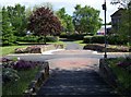
Garden In Centre of Roundabout, Stafford
On the Stafford Ring Road near Gaol Square
Image: © Geoff Pick
Taken: 7 May 2009
0.05 miles
2
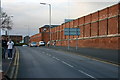
Stafford Prison
Stafford Prison on Gaol Road
Image: © Stephen Pearce
Taken: 13 Nov 2006
0.05 miles
3
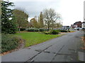
North Gate, Stafford
An area of open gardens and civic space, left at the site of the medieval North Gate entrance to the town, which is also seen in Image
Image: © Richard Law
Taken: 4 Nov 2020
0.06 miles
4

Western perimeter wall of Stafford Prison - Gaol Road
The rather impressive western perimeter wall of the prison, which were built in the 1790s, altered in the 1950s (turrets in a number of angles were demolished) and Grade II listed https://britishlistedbuildings.co.uk/101211998-perimeter-walls-to-west-and-north-of-hm-prison-stafford-coton-ward#.YaQD9NDP3IU & https://historicengland.org.uk/listing/the-list/list-entry/1211998 in 1971.
Image: © Richard Law
Taken: 4 Nov 2020
0.06 miles
5

North Gate
This crossing of footpaths lies close to the site of the gate that guarded the causeway access through marshes on the northern approach to the original town.
Image: © David Rogers
Taken: 15 Aug 2008
0.06 miles
6
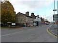
Looking north up Gaol Road
The gable wall on the other side of the road has a rather good example of a ghost sign advertisement. The words "Wills's Gold Flake Cigarettes" are obviously most prominent, but the older wording at the top also has the words "tobacco" and "tobacconists" in it, which suggests there may have been such a business in the premises for quite a while some years ago.
Image: © Richard Law
Taken: 4 Nov 2020
0.06 miles
7
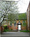
Friends' Meeting House
The Friends' Meeting House [Quakers]in Stafford dates from 1730 and is still in use.
Image: © Simon Huguet
Taken: 29 Apr 2008
0.07 miles
8
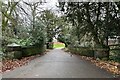
Bridge on former carriage drive to hospital
This is the original nineteenth-century bridge over the Pearl Brook leading to the former St George's Hospital, now developed into housing.
Image: © Jonathan Hutchins
Taken: 3 Jan 2023
0.08 miles
9
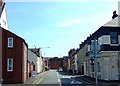
County Road, Stafford
Looking from Foregate along County Street towards the main gate of Stafford Prison.
Image: © Simon Huguet
Taken: 26 Jul 2008
0.09 miles
10
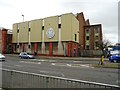
HV DC Test Facility
The former Stafford Power Station closed by MEB 1959 was taken over by the English Electric Company to test their mercury-arc valve equipment for power station switchgear. The old boilerhouse and equipment rooms had the height and space required. The brick extension on the right adjacent to Glover Street dates from 1939.
Image: © John M
Taken: 28 Oct 2017
0.09 miles