IMAGES TAKEN NEAR TO
Foregate Street, STAFFORD, ST16 2PT
Introduction
This page details the photographs taken nearby to Foregate Street, ST16 2PT by members of the Geograph project.
The Geograph project started in 2005 with the aim of publishing, organising and preserving representative images for every square kilometre of Great Britain, Ireland and the Isle of Man.

There are currently over 7.5m images from over14,400 individuals and you can help contribute to the project by visiting https://www.geograph.org.uk
Image Map (Loading...)


Getting Data...Please wait
Leaflet Map data © OpenStreetMap
Images are licensed for reuse under creativecommons.org/licenses/by-sa/2.0
Notes
- Clicking on the map will re-center to the selected point.
- The higher the marker number, the further away the image location is from the centre of the postcode.
Image Listing (105 Images Found)
Images are licensed for reuse under creativecommons.org/licenses/by-sa/2.0
Image
Details
Distance
1
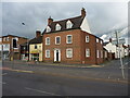
62 & 63 Foregate Street, Stafford
Extensive restoration work in the 20th century hides much of the character, but the core of this house dates from the late 17th century, and retains a number of wooden beams and traces of a barrel-vaulted ceiling, amongst other interior features. It was Grade II listed https://britishlistedbuildings.co.uk/101195383-62-and-63-foregate-street-stafford-coton-ward#.YZPxfmDP3IU & https://historicengland.org.uk/listing/the-list/list-entry/1195383 in 1971.
Image: © Richard Law
Taken: 4 Nov 2020
0.00 miles
2
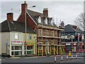
Scaffolding to 62-63 Foregate Street
Hidden behind the late 19th century brickwork lies a c1698 house, Grade II listed.
Image: © John M
Taken: 28 Oct 2017
0.01 miles
3
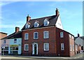
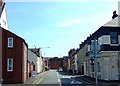
House on Foregate Street, Stafford.
Now refurbished and converted to offices this rather grand town house, probably built in the late C18th or early C19th looks a little out of place in its current surroundings.
Image: © Simon Huguet
Taken: 26 Jul 2008
0.02 miles
5
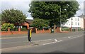
Crooked Bridge Road
Crooked Bridge Road at the junction of Gaol Road. Stafford Prison is on the right, in the distance is Prospect Road.
Image: © Stephen Pearce
Taken: 13 Nov 2006
0.03 miles
6
HMP Stafford
The Gates to Stafford Prison on Gaol Road, Stafford.
Image: © Stephen Pearce
Taken: 13 Nov 2006
0.03 miles
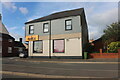
7
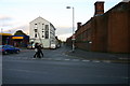
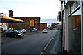
Foregate Street, Stafford
Jehovah's Witnesses Kingdom Hall is on the left.
Image: © David Howard
Taken: 19 Jun 2022
0.04 miles
8
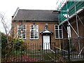
The Quaker Friends' Meeting House on Foregate Street
This small Meeting house dates from 1730, and was Grade II* listed https://britishlistedbuildings.co.uk/101211911-friends-meeting-house-stafford-coton-ward#.YZPz-GDP3IU & https://historicengland.org.uk/listing/the-list/list-entry/1211911 in 1951. It retains many of its original interior features, and is described as "Well preserved...best in Staffordshire" in the listing.
Image: © Richard Law
Taken: 4 Nov 2020
0.04 miles
9
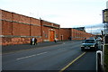
Gaol Road, Stafford
Gaol Road looking south towards Stafford town centre, Crooked Bridge Road is off to the left beyond the petrol station with Stafford Prison dominating the area.
Image: © Stephen Pearce
Taken: 13 Nov 2006
0.04 miles
10
County Road, Stafford
Looking from Foregate along County Street towards the main gate of Stafford Prison.
Image: © Simon Huguet
Taken: 26 Jul 2008
0.05 miles