IMAGES TAKEN NEAR TO
Castle Street, STAFFORD, ST16 2ED
Introduction
This page details the photographs taken nearby to Castle Street, ST16 2ED by members of the Geograph project.
The Geograph project started in 2005 with the aim of publishing, organising and preserving representative images for every square kilometre of Great Britain, Ireland and the Isle of Man.

There are currently over 7.5m images from over14,400 individuals and you can help contribute to the project by visiting https://www.geograph.org.uk
Image Map (Loading...)


Getting Data...Please wait
Leaflet Map data © OpenStreetMap
Images are licensed for reuse under creativecommons.org/licenses/by-sa/2.0
Notes
- Clicking on the map will re-center to the selected point.
- The higher the marker number, the further away the image location is from the centre of the postcode.
Image Listing (190 Images Found)
Images are licensed for reuse under creativecommons.org/licenses/by-sa/2.0
Image
Details
Distance
1
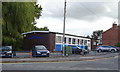
Stafford Conservative Association
On Castle Street.
Image: © JThomas
Taken: 7 Sep 2019
0.02 miles
3
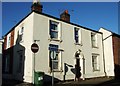
Castle Street
Many of the corner plots in this cluster of C19th terraced streets are filled with somewhat grander double fronted houses.
Image: © Simon Huguet
Taken: 20 Jan 2009
0.02 miles
5
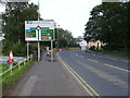
Doxey Road, Stafford
Approaching roundabout.
Image: © JThomas
Taken: 7 Sep 2019
0.05 miles
6

River Sow
Looking downstream from the bridge at Doxey Road.
Image: © David Dixon
Taken: 12 Apr 2011
0.05 miles
7
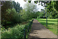
River Sow Leisure Route
This path along the bank of the River Sow, a tributary of the Trent, is signed as the 'River Sow Leisure Route' through Stafford town centre. This is the view from beside the Broad Eye bridge.
Image: © Stephen McKay
Taken: 24 Sep 2020
0.05 miles
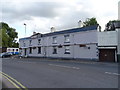
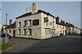
8
Stafford - Railway Inn
On Castle Street.
Image: © Dave Bevis
Taken: 19 Aug 2011
0.06 miles
9
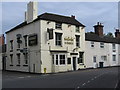
Railway Inn, Castletown, Stafford
The Railway Inn is an end-of-terrace Victorian pub dominating the surrounding buildings. It is at the junction of Castle Street and Castle View and was opened in 1848
Image: © Rod Grealish
Taken: 17 Oct 2023
0.06 miles
10
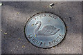
River Sow Leisure Route
This marker is laid into the path at the photographer's feet in this view: Image
Image: © Stephen McKay
Taken: 24 Sep 2020
0.06 miles