IMAGES TAKEN NEAR TO
Victoria Road, STAFFORD, ST16 2BY
Introduction
This page details the photographs taken nearby to Victoria Road, ST16 2BY by members of the Geograph project.
The Geograph project started in 2005 with the aim of publishing, organising and preserving representative images for every square kilometre of Great Britain, Ireland and the Isle of Man.

There are currently over 7.5m images from over14,400 individuals and you can help contribute to the project by visiting https://www.geograph.org.uk
Image Map (Loading...)


Getting Data...Please wait
Leaflet Map data © OpenStreetMap
Images are licensed for reuse under creativecommons.org/licenses/by-sa/2.0
Notes
- Clicking on the map will re-center to the selected point.
- The higher the marker number, the further away the image location is from the centre of the postcode.
Image Listing (643 Images Found)
Images are licensed for reuse under creativecommons.org/licenses/by-sa/2.0
Image
Details
Distance
1
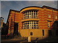
Stafford Crown Court
From the same mini-roundabout as Image The building dates from 1990 and was designed by Associated Architects of Birmingham to complement the Tenterbanks college building to its left.
Image: © Derek Harper
Taken: 6 Sep 2012
0.01 miles
2
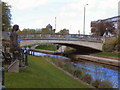
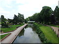
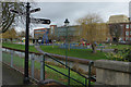
River Sow, Victoria Road Bridge
Looking upstream to the bridge at Victoria Road, from within Victoria Park. The statue on the left is of Izaac Walton, an English writer who was born in Stafford. He is best known as the author of The Compleat Angler.
Image: © David Dixon
Taken: 12 Apr 2011
0.02 miles
3
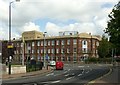
Stafford County Technical College building
Now simply Stafford College. Construction started in 1937 but it was still a shell when war broke out. It was temporarily used as a hospital for United States forces and was only fitted out for use in 1946. Listed Grade II.
Image: © Alan Murray-Rust
Taken: 23 Aug 2017
0.02 miles
4
Stafford College
College buildings on Tenterbanks.
Image: © JThomas
Taken: 7 Oct 2017
0.02 miles
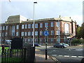
6
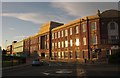
Stafford College
Another view of the college's Tenterbanks Buildings shown in Image, lit by evening sunlight. "The shell of the building was completed in 1937, after which it was used as an American army hospital during the war, then completed afterwards" http://list.english-heritage.org.uk/resultsingle.aspx?uid=1212835&searchtype=mapsearch .
Image: © Derek Harper
Taken: 6 Sep 2012
0.03 miles
7
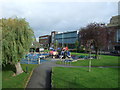
Children's playground, Stafford
Near the River Sow.
Image: © JThomas
Taken: 7 Oct 2017
0.03 miles
8
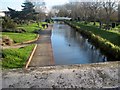
River Sow, Stafford
Taken on the bridge on Victoria Road, looking along the Sow as it flows through Victoria Park.
Image: © Tricia Neal
Taken: 4 Dec 2013
0.04 miles
9
River Sow, Stafford
The River flows past Victoria Park and its children's play equipment, with buildings on Tenterbanks in the background.
Image: © Stephen McKay
Taken: 28 Feb 2015
0.04 miles
10
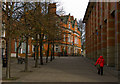
Victoria Road, Stafford, Looking towards town centre.
Image: © Tim Marshall
Taken: 3 Feb 2009
0.04 miles