IMAGES TAKEN NEAR TO
Harry Kerr Drive, STAFFORD, ST16 1WT
Introduction
This page details the photographs taken nearby to Harry Kerr Drive, ST16 1WT by members of the Geograph project.
The Geograph project started in 2005 with the aim of publishing, organising and preserving representative images for every square kilometre of Great Britain, Ireland and the Isle of Man.

There are currently over 7.5m images from over14,400 individuals and you can help contribute to the project by visiting https://www.geograph.org.uk
Image Map (Loading...)


Getting Data...Please wait
Leaflet Map data © OpenStreetMap
Images are licensed for reuse under creativecommons.org/licenses/by-sa/2.0
Notes
- Clicking on the map will re-center to the selected point.
- The higher the marker number, the further away the image location is from the centre of the postcode.
Image Listing (5 Images Found)
Images are licensed for reuse under creativecommons.org/licenses/by-sa/2.0
Image
Details
Distance
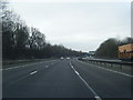
2
M6 motorway in cutting near Creswell Grove
Image: © Peter Whatley
Taken: 21 Jan 2011
0.18 miles
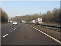
3
Creswell : M6 Motorway
The M6 Motorway between Junction 14 (Stafford North) and Junction 15.
Image: © Lewis Clarke
Taken: 22 Sep 2019
0.19 miles
4
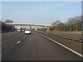
M6 Motorway - accommodation bridge near Cresswell Grove
An early design (probably original from 1962) with pillars both in the central reservation and encroaching on the emergency lanes ("hard shoulders").
Image: © Peter Whatley
Taken: 21 Jan 2011
0.21 miles
