IMAGES TAKEN NEAR TO
Beton Way, STAFFORD, ST16 1TJ
Introduction
This page details the photographs taken nearby to Beton Way, ST16 1TJ by members of the Geograph project.
The Geograph project started in 2005 with the aim of publishing, organising and preserving representative images for every square kilometre of Great Britain, Ireland and the Isle of Man.

There are currently over 7.5m images from over14,400 individuals and you can help contribute to the project by visiting https://www.geograph.org.uk
Image Map
Images are licensed for reuse under creativecommons.org/licenses/by-sa/2.0
Notes
- Clicking on the map will re-center to the selected point.
- The higher the marker number, the further away the image location is from the centre of the postcode.
Image Listing (12 Images Found)
Images are licensed for reuse under creativecommons.org/licenses/by-sa/2.0
Image
Details
Distance
2
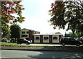
The Staffordshire Bull, Parkside.
Named for Staffordshire's famous Bull Terriers.
Image: © Simon Huguet
Taken: 18 Sep 2008
0.07 miles
3
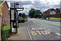
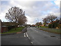
Bus stop on Parkside Avenue, Parkside Estate
The Parkside Estate, consisting mainly of owner-occupied detached and semi-detached houses around 50 years old, is arranged as a series of cul-de-sacs leading off a semi-circular road called Parkside Avenue. There is a shopping parade, primary and secondary schools, and a pub.
A regular bus service operated by Arriva runs in a clockwise direction via Parkside Avenue and this is the first stop on the road. The very unusual 'drivers should not wait time at this point' plate is intriguing, especially as this would be the obvious point at which to do so - before commencing the journey back into the centre of Stafford. It has probably come about as a result of residents' complaints, who are perhaps not too keen on buses idling for lengthy periods close to their houses. It could be that the company has erected the sign as a way of emphasising that it is taking action rather than confining itself to a notice in the garage.
Image: © Stephen McKay
Taken: 24 Sep 2020
0.12 miles
4
Linksfield Grove, Parkside
A residential cul de sac off Parkside Avenue, the estate's main distributor road.
Image: © Richard Vince
Taken: 11 Jan 2014
0.12 miles
5
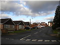
Parkside Avenue, Parkside
The estate's distributor road, seen from the junction with Ashdale Drive (left). As seems common in estates of this vintage, very little housing actually fronts onto Parkside Avenue itself.
Image: © Richard Vince
Taken: 11 Jan 2014
0.14 miles
6
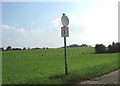
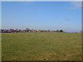
Stafford Common
'No Golf' An interesting sign at the side of the common, presumably to prevent stray balls hitting walkers or being eaten by the cattle and horses that graze the common proper.
To judge by the spotty appearance of the round upper sign similar strictures may soon be needed for airguns!
Image: © Simon Huguet
Taken: 18 Sep 2008
0.20 miles
7
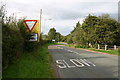
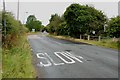
Common Road approaching Beaconside, Stafford
This is Common Road on the approach to the junction with Beaconside, north Stafford.
Image: © Stephen Pearce
Taken: 7 Oct 2006
0.22 miles
8
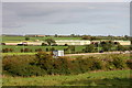
RAF Stafford
This is a view of RAF Stafford (the RAF is no longer in residence here - 2006) from Common Road. In the distance on the right is Hopton. In the foreground is Beaconside.
Image: © Stephen Pearce
Taken: 7 Oct 2006
0.22 miles
9
Common Road to A513 Beaconside Ring Road
Image: © Mick Malpass
Taken: 17 Jul 2011
0.22 miles
10
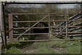
Beaconside Underpass
Livestock underpass connecting the north and south of Stafford Common beneath the A513/Beaconside.
Image: © Richard
Taken: 9 Mar 2019
0.22 miles