IMAGES TAKEN NEAR TO
Taplin Close, STAFFORD, ST16 1NW
Introduction
This page details the photographs taken nearby to Taplin Close, ST16 1NW by members of the Geograph project.
The Geograph project started in 2005 with the aim of publishing, organising and preserving representative images for every square kilometre of Great Britain, Ireland and the Isle of Man.

There are currently over 7.5m images from over14,400 individuals and you can help contribute to the project by visiting https://www.geograph.org.uk
Image Map (Loading...)


Getting Data...Please wait
Leaflet Map data © OpenStreetMap
Images are licensed for reuse under creativecommons.org/licenses/by-sa/2.0
Notes
- Clicking on the map will re-center to the selected point.
- The higher the marker number, the further away the image location is from the centre of the postcode.
Image Listing (9 Images Found)
Images are licensed for reuse under creativecommons.org/licenses/by-sa/2.0
Image
Details
Distance
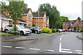
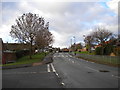
2
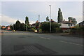
Housing on west side of Stone Road Stafford
A variety of houses on the Stone Road mainly build in the 1920's and 30's. Crispin Court care home is in the distance to the lest of the tree.
Image: © Rod Grealish
Taken: 17 Oct 2023
0.11 miles
3
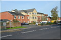
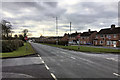
Crispin Court Care Home, Stone Road, Stafford
Crispin Court Care Home was built in 2016 and is run by Avery Healthcare Ltd. It was rated as outstanding by the Care Quality Commission after an inspection in January 2020.
Image: © Rod Grealish
Taken: 17 Oct 2023
0.12 miles
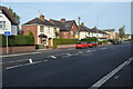
7
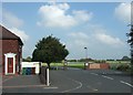
Entrance to Sir Graham Balfour High School
The school was recently rebuilt and is blessed with very large playing fields.
The house on the left displays the impressive assortment of wheelie bins Stafford residents have to use for their rubbish [green], re-cycling [blue] and garden waste [brown].
Image: © Simon Huguet
Taken: 18 Sep 2008
0.22 miles
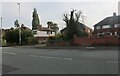
9
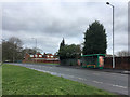
Parkside Avenue, Parkside
The estate's distributor road, seen from the junction with Ashdale Drive (left). As seems common in estates of this vintage, very little housing actually fronts onto Parkside Avenue itself.
Image: © Richard Vince
Taken: 11 Jan 2014
0.25 miles