IMAGES TAKEN NEAR TO
Carson Way, STAFFORD, ST16 1LL
Introduction
This page details the photographs taken nearby to Carson Way, ST16 1LL by members of the Geograph project.
The Geograph project started in 2005 with the aim of publishing, organising and preserving representative images for every square kilometre of Great Britain, Ireland and the Isle of Man.

There are currently over 7.5m images from over14,400 individuals and you can help contribute to the project by visiting https://www.geograph.org.uk
Image Map
Images are licensed for reuse under creativecommons.org/licenses/by-sa/2.0
Notes
- Clicking on the map will re-center to the selected point.
- The higher the marker number, the further away the image location is from the centre of the postcode.
Image Listing (16 Images Found)
Images are licensed for reuse under creativecommons.org/licenses/by-sa/2.0
Image
Details
Distance
1
New housing development in Castletown
This was a greenfield development.
Image: © Bill Boaden
Taken: 2 Apr 2011
0.04 miles
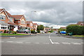
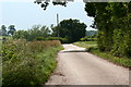
2
Private Road near Martin Drive, Castletown, Stafford
Image: © Mick Malpass
Taken: 17 Jul 2011
0.10 miles
3
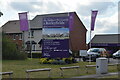
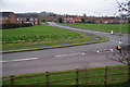
Entrance to new housing site on Burleyfields, Stafford
The image shows the sales sign with show homes on the left and the sales office on the right. The main route through the development is an extension of the existing Martin Drive, Stafford.
Image: © Rod Grealish
Taken: 26 Aug 2022
0.13 miles
5
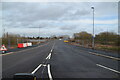
Unicorn Way Stafford newly opened
The view shows the newly opened Unicorn Way from its junction with Martin Drive to the Doxey Road railway bridge. The Way forms part of the Western Access route which gives access to new development land and provides a bypass around the town centre. The Way is named after the Unicorn company whose premises were demolished to make way for the route.
Image: © Rod Grealish
Taken: 16 Feb 2021
0.14 miles
6
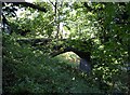
Abandoned Railway Bridge, Stafford
Hiding amongst decades of tree growth lies an old abandoned railway bridge, once crossing the Stafford to Newport branch of the London and North Western Railway Co (later LMS). Opened in 1849 and closed in the mid 1960's few signs that a railway ever ran here now exist. Some of the line has been converted to a cycleway / footpath.
Image: © Tim Marshall
Taken: 17 Oct 2008
0.16 miles
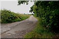
8
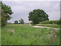
Track to The Way for the Millennium
This farm track and public right of way leads to Burleyfields Farm with 'The Way for the Millennium', a disused railway track walk and cycleway, starting where the tree is at the end of this view.
Image: © Stephen Pearce
Taken: 19 Jun 2007
0.19 miles