IMAGES TAKEN NEAR TO
Holmcroft Road, STAFFORD, ST16 1JE
Introduction
This page details the photographs taken nearby to Holmcroft Road, ST16 1JE by members of the Geograph project.
The Geograph project started in 2005 with the aim of publishing, organising and preserving representative images for every square kilometre of Great Britain, Ireland and the Isle of Man.

There are currently over 7.5m images from over14,400 individuals and you can help contribute to the project by visiting https://www.geograph.org.uk
Image Map (Loading...)


Getting Data...Please wait
Leaflet Map data © OpenStreetMap
Images are licensed for reuse under creativecommons.org/licenses/by-sa/2.0
Notes
- Clicking on the map will re-center to the selected point.
- The higher the marker number, the further away the image location is from the centre of the postcode.
Image Listing (18 Images Found)
Images are licensed for reuse under creativecommons.org/licenses/by-sa/2.0
Image
Details
Distance
1
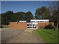
Holmcroft Library
Just along the grass from Image
Image: © Derek Harper
Taken: 7 Sep 2012
0.04 miles
2
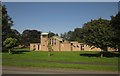
St Bertelin's Church, Eccleshall Road
Built in the 1950s and dedicated in 1956 St Bertelin's is part of the Stafford Team Ministry [Church of England].
Bertelin is an unusual dedication. He was a holy man who is reputed to have built a chapel in Stafford sometime in the C7th or C8th century. The foundations of what is believed to have been this building or its successor can be seen in St Mary's churchyard in the town centre. He is believed to have died at Ilam in Derbyshire and to be buried there.
Image: © Simon Huguet
Taken: 26 Jul 2008
0.08 miles
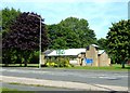
3
St Bertelin's Church, Stafford
This view of the unusually-dedicated church shown in Image is from across Holmcroft Road. I attempted to arrange it so that the person sitting on the bench was hidden by a tree - but it's a very small tree.
Image: © Derek Harper
Taken: 7 Sep 2012
0.08 miles
4
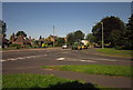
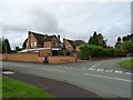
Junction and tractor, Eccleshall Road
Croft Road meets the A5013 at this T-junction. The tractor driving through suburbia is a reminder of the importance of agriculture to this part of the county. It seems to be towing a Claas Quadrant baler.
Image: © Derek Harper
Taken: 7 Sep 2012
0.10 miles
5
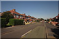
Second Avenue, Holmcroft
Stafford suburbs. Dare I say the imaginative road name matches the architecture?
Image: © Derek Harper
Taken: 7 Sep 2012
0.11 miles
6
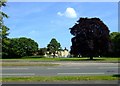
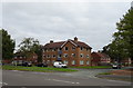
Tillington Hall Hotel, Stafford
Formerly an modest C19th gentleman's residence Tillington Hall has been greatly extended and is now a Hotel. Its former parkland forms a public open space adjoining Eccleshall Road.
Image: © Simon Huguet
Taken: 26 Jul 2008
0.13 miles
7
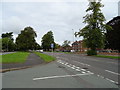
Eccleshall Road (A5013), Stafford
At the junction with Pulteney Drive.
Image: © JThomas
Taken: 7 Sep 2019
0.16 miles
10
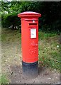
Postbox, Eccleshall Road, Stafford
This un-numbered George V box is probably contemporary with most of the houses in the 1930s ribbon development along this road out of Stafford.
Image: © Simon Huguet
Taken: 28 Jun 2008
0.19 miles