IMAGES TAKEN NEAR TO
Hylton Road, STAFFORD, ST16 1GT
Introduction
This page details the photographs taken nearby to Hylton Road, ST16 1GT by members of the Geograph project.
The Geograph project started in 2005 with the aim of publishing, organising and preserving representative images for every square kilometre of Great Britain, Ireland and the Isle of Man.

There are currently over 7.5m images from over14,400 individuals and you can help contribute to the project by visiting https://www.geograph.org.uk
Image Map (Loading...)


Getting Data...Please wait
Leaflet Map data © OpenStreetMap
Images are licensed for reuse under creativecommons.org/licenses/by-sa/2.0
Notes
- Clicking on the map will re-center to the selected point.
- The higher the marker number, the further away the image location is from the centre of the postcode.
Image Listing (4 Images Found)
Images are licensed for reuse under creativecommons.org/licenses/by-sa/2.0
Image
Details
Distance
1
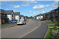
Martin Drive, Burleyfields, Stafford
Burleyfields is a new housing development to the west of Stafford. The image shows the first part of the development on Martin Drive.
Image: © Rod Grealish
Taken: 26 Aug 2022
0.16 miles
2
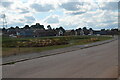
Burleyfields Estate, Stafford
Burleyfields is a new housing development to the west of Stafford. The view shows the first stage of development with Martin Drive in foreground and a balancing pond in the centre of the image on the opposite side of Martin Drive. The balancing pond acts as a temporary storage for watercourses avoiding flood further downstream
Image: © Rod Grealish
Taken: 26 Aug 2022
0.19 miles
4
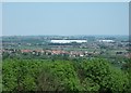
Looking north from Stafford Castle
Taken from the keep, looking across the trees that cloak the mote towards Doxey. Beyond Doxey the overhead gantries of the West Coast mainline can be made out against the green strip of Doxey Marshes Nature Reserve, followed by the Cresswell and Tillington areas of Stafford.
The M6 motorway can be seen winding through the left side of the picture, which gives some scale to the enormous buildings of Primepoint 14, a development that developers and planners assured local residents would not have any detrimental impact on the Stafford skyline!
Image: © Simon Huguet
Taken: 31 May 2009
0.24 miles