IMAGES TAKEN NEAR TO
Till View, STAFFORD, ST16 1GG
Introduction
This page details the photographs taken nearby to Till View, ST16 1GG by members of the Geograph project.
The Geograph project started in 2005 with the aim of publishing, organising and preserving representative images for every square kilometre of Great Britain, Ireland and the Isle of Man.

There are currently over 7.5m images from over14,400 individuals and you can help contribute to the project by visiting https://www.geograph.org.uk
Image Map
Images are licensed for reuse under creativecommons.org/licenses/by-sa/2.0
Notes
- Clicking on the map will re-center to the selected point.
- The higher the marker number, the further away the image location is from the centre of the postcode.
Image Listing (21 Images Found)
Images are licensed for reuse under creativecommons.org/licenses/by-sa/2.0
Image
Details
Distance
2
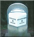
Replica Milestone by the A34, Stone Road, Stafford
Metal plate attached to stone post by the A34, in parish of Creswell (Stafford District), Trinity Fields, Stone Road, North of lay-by, North of Stafford by-pass, on the verge in front of hedge, on West side of road. Stafford V iron plate on stone, the original was erected by the Stone, Stafford & Penkridge turnpike trust in the 19th century.
The original stone was placed at the Northern end of the lay-by during roadworks, however, it disappeared between 2011 and 2012. By 2015 a new pavement/cycleway was installed and a new stone and plate was set up slightly further North of the lay-by. This photo is of the new stone.
Inscription reads:-
: STONE / 5 / MILES : : TILLINGTON : : STAFFORD 2 / MILES :
The original stone was Grade II listed.
List Entry Number: 1392684
https://historicengland.org.uk/listing/the-list/list-entry/1392684
Milestone Society National ID: ST_SNST05
Image: © J Higgins
Taken: Unknown
0.05 miles
3
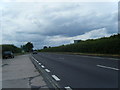
A34 Stone Road
Heading north, away from Stafford.
Image: © David Dixon
Taken: 4 Feb 2019
0.06 miles
4
Hurricane Close, Stafford Audi
Car dealership on Hurricane Close.
Image: © David Dixon
Taken: 4 Feb 2019
0.13 miles
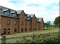
5
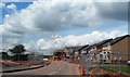
New Housing Development off the A513
Image: © Anthony Parkes
Taken: 13 Jun 2014
0.16 miles
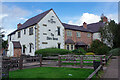
6
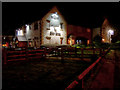
The Shire Horse restaurant from Mustang Drive, Stafford
Viewed from Mustang Drive, the access route to the Prime Point business park, this restaurant is part of the Chef and Brewer chain. The wonky roofline is not due to subsidence or poor construction (or, indeed, a faulty camera lens) but is a feature to add antiquity to a 30-year-old building. There is an adjoining Premier Inn behind the restaurant just visible on the right of the picture,
Image: © Rod Grealish
Taken: 17 Oct 2023
0.18 miles
7
The Shire Horse
Chef and Brewer restaurant attached to the Stafford North (Hurricane) Premier Inn.
Image: © David Dixon
Taken: 3 Feb 2019
0.18 miles
8
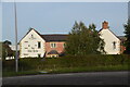
The Shire Horse Inn
A traditional old inn built in 2002 for Chef and Brewer.
Image: © Neil Lewin
Taken: 11 Aug 2006
0.18 miles
9
Premier Travel Inn 'Hurricane'
So named as it is on Hurricane Way, it is right next to the Shire Horse Inn. The futuristic building behind is an Audi showroom.
Image: © Neil Lewin
Taken: 11 Aug 2006
0.18 miles
10
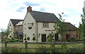
The Shire Horse, Stafford
This pub, part of the Chef & Brewer chain, was purpose built in 2002 but has been designed to have a traditional 'country pub' feel. It is pretty much surrounded by a business park and is convenient for the M6.
Image: © Stephen McKay
Taken: 24 Sep 2020
0.19 miles