IMAGES TAKEN NEAR TO
Dunlin Gardens, STAFFORD, ST16 1FY
Introduction
This page details the photographs taken nearby to Dunlin Gardens, ST16 1FY by members of the Geograph project.
The Geograph project started in 2005 with the aim of publishing, organising and preserving representative images for every square kilometre of Great Britain, Ireland and the Isle of Man.

There are currently over 7.5m images from over14,400 individuals and you can help contribute to the project by visiting https://www.geograph.org.uk
Image Map
Images are licensed for reuse under creativecommons.org/licenses/by-sa/2.0
Notes
- Clicking on the map will re-center to the selected point.
- The higher the marker number, the further away the image location is from the centre of the postcode.
Image Listing (17 Images Found)
Images are licensed for reuse under creativecommons.org/licenses/by-sa/2.0
Image
Details
Distance
1
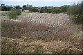
Reed beds near Doxey
The major Doxey Marshes are on the other side of the village, but you wouldn't want to try walking over this.
Image: © Bill Boaden
Taken: 2 Apr 2011
0.09 miles
4
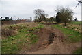
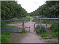
The end of the line?
The Way for the Millennium has been following the route of the old Wellington to Stafford railway line, but has to leave it here. Mountain bikers have used this section.
Image: © Bill Boaden
Taken: 2 Apr 2011
0.17 miles
6
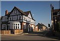
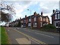
The Crescent, Doxey
A not exactly crescent-shaped no through road off Doxey Road (foreground), but it does go round a right-angled bend.
Image: © Derek Harper
Taken: 7 Sep 2012
0.18 miles
9
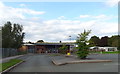
Burleyfields Estate, Stafford
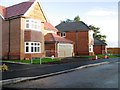
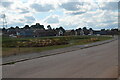
Burleyfields is a new housing development to the west of Stafford. The view shows the first stage of development with Martin Drive in foreground and a balancing pond in the centre of the image on the opposite side of Martin Drive. The balancing pond acts as a temporary storage for watercourses avoiding flood further downstream
Image: © Rod Grealish
Taken: 26 Aug 2022
0.20 miles