IMAGES TAKEN NEAR TO
Bradbury Rise, STAFFORD, ST16 1EL
Introduction
This page details the photographs taken nearby to Bradbury Rise, ST16 1EL by members of the Geograph project.
The Geograph project started in 2005 with the aim of publishing, organising and preserving representative images for every square kilometre of Great Britain, Ireland and the Isle of Man.

There are currently over 7.5m images from over14,400 individuals and you can help contribute to the project by visiting https://www.geograph.org.uk
Image Map
Images are licensed for reuse under creativecommons.org/licenses/by-sa/2.0
Notes
- Clicking on the map will re-center to the selected point.
- The higher the marker number, the further away the image location is from the centre of the postcode.
Image Listing (14 Images Found)
Images are licensed for reuse under creativecommons.org/licenses/by-sa/2.0
Image
Details
Distance
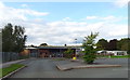
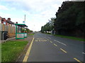
2
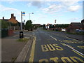
Bus stop on Doxey Road
At the junction with Bradbury Rise.
Image: © JThomas
Taken: 7 Sep 2019
0.05 miles
3
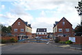
Mallard Walk
New homes under construction off Doxey Road.
Image: © JThomas
Taken: 7 Sep 2019
0.07 miles
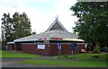
8
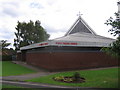
Doxey Parish Church
Parish church in Doxey, which is a village now considered a suburb of Stafford
Image: © Andrew Spenceley
Taken: 27 Aug 2006
0.16 miles