IMAGES TAKEN NEAR TO
The Glades, Festival Way, STOKE-ON-TRENT, ST1 5SQ
Introduction
This page details the photographs taken nearby to The Glades, Festival Way, ST1 5SQ by members of the Geograph project.
The Geograph project started in 2005 with the aim of publishing, organising and preserving representative images for every square kilometre of Great Britain, Ireland and the Isle of Man.

There are currently over 7.5m images from over14,400 individuals and you can help contribute to the project by visiting https://www.geograph.org.uk
Image Map
Images are licensed for reuse under creativecommons.org/licenses/by-sa/2.0
Notes
- Clicking on the map will re-center to the selected point.
- The higher the marker number, the further away the image location is from the centre of the postcode.
Image Listing (46 Images Found)
Images are licensed for reuse under creativecommons.org/licenses/by-sa/2.0
Image
Details
Distance
1
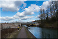
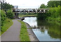
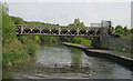
New Bridge Over An Old Canal, Trent Mersey Canal, Festival Park
New 2022 Bridge over the 1777 Canal. It is going to link the A500, Wolstanton Junction, with Festival Park.
Image: © Brian Deegan
Taken: 5 Mar 2022
0.06 miles
2
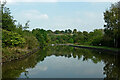
Trent and Mersey Canal south-east of Middleport
Looking east from near Newport Lane Bridge (No 123) as the canal meanders towards Etruria, Stoke-on-Trent and Stone. The white marker past those large trees on the left is at the junction with the former Burslem Canal. Following a breach in 1961 it was closed, then filled in later. There are proposals to restore it.
Image: © Roger Kidd
Taken: 9 Sep 2014
0.07 miles
3
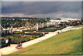
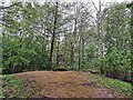
Stoke Garden Festival 1986
This second garden festival reclaimed 180 acres of derelict industrial land on part of the site belonging to Shelton Bar Steelworks.The woodland is now maturing alongside original gardens, with some retail and offices.The rest of the steelworks site is now ready for development as Festival Waters.
Image: © Carol Walker
Taken: Unknown
0.08 miles
4
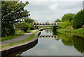
Canal north of Etruria, Stoke-on-Trent
Looking towards Burslem. There is a very large "brown field" site off to the left, waiting for redevelopment, much of it having been a former steelworks. The bridge is numbered 119C, Grange Bridge. It carried a single track railway line from the former Grange Colliery.
Image: © Roger D Kidd
Taken: 3 Sep 2014
0.10 miles
5
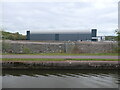
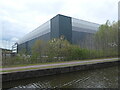
National Veterinary Services Ltd, east elevation
One of several similar new buildings developed by Modwen on the west bank of the Trent & Mersey canal. This used to be the site of a steelworks.
Image: © Christine Johnstone
Taken: 1 May 2023
0.10 miles
6
Shelton Bar Trigpoint
TP5931 - Shelton Bar.
http://trigpointing.uk/trig/5931
Image: © Brian Deegan
Taken: 24 Apr 2019
0.10 miles
7
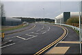
Etruria Valley Link Road
The new Etruria Valley Link road, connecting Festival Park to the A500. The road is still under construction, and due to open later this year.
Image: © Andrew Woodvine
Taken: 6 Nov 2022
0.11 miles
8
Disused railway bridge across the Trent & Mersey Canal
Image: © Mat Fascione
Taken: 11 Jul 2015
0.11 miles
9
Stanton Steel Works Bridge
Trent and Mersey Canal, adjacent to former Stanton Steel Works, now demolished
Image: © Mike Todd
Taken: 28 Apr 2011
0.11 miles
10
National Veterinary Services Ltd, south-east corner
One of several similar new buildings developed by Modwen on the west bank of the Trent & Mersey canal. This used to be the site of a steelworks.
Image: © Christine Johnstone
Taken: 1 May 2023
0.11 miles