IMAGES TAKEN NEAR TO
Longton Road, STONE, ST15 8TB
Introduction
This page details the photographs taken nearby to Longton Road, ST15 8TB by members of the Geograph project.
The Geograph project started in 2005 with the aim of publishing, organising and preserving representative images for every square kilometre of Great Britain, Ireland and the Isle of Man.

There are currently over 7.5m images from over14,400 individuals and you can help contribute to the project by visiting https://www.geograph.org.uk
Image Map
Images are licensed for reuse under creativecommons.org/licenses/by-sa/2.0
Notes
- Clicking on the map will re-center to the selected point.
- The higher the marker number, the further away the image location is from the centre of the postcode.
Image Listing (5 Images Found)
Images are licensed for reuse under creativecommons.org/licenses/by-sa/2.0
Image
Details
Distance
1
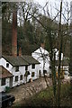
Ivy Mill
An impressive range of buildings with a large weir and a tall chimney crammed into the valley bottom.
Image: © Chris Allen
Taken: 26 Jan 2008
0.02 miles
3
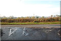
Road Junction looking in the direction of Oulton
Image: © Mick Malpass
Taken: 13 Nov 2011
0.13 miles
4
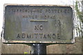
Redundant sign
The building that this pertained too is long gone - Stone Water Works.
Image: © Chris Allen
Taken: 26 Jan 2008
0.15 miles
5
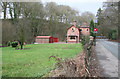
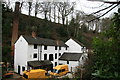
Site of Stone water Works.
The book Industrial Archaeology of North Staffordshire by W J Thompson (not dated) shows a fine steam pumping station with a tall chimney. I reckon this was on the grassy area. The distant house is called "Pump House" and would have been the superintendent's house. The architecture is municipal and there is a water authority keep out sign. A rapidly moving automobile has activated the automatic slow down sign.
Image: © Chris Allen
Taken: 26 Jan 2008
0.18 miles