IMAGES TAKEN NEAR TO
Park View, STONE, ST15 0QG
Introduction
This page details the photographs taken nearby to Park View, ST15 0QG by members of the Geograph project.
The Geograph project started in 2005 with the aim of publishing, organising and preserving representative images for every square kilometre of Great Britain, Ireland and the Isle of Man.

There are currently over 7.5m images from over14,400 individuals and you can help contribute to the project by visiting https://www.geograph.org.uk
Image Map (Loading...)


Getting Data...Please wait
Leaflet Map data © OpenStreetMap
Images are licensed for reuse under creativecommons.org/licenses/by-sa/2.0
Notes
- Clicking on the map will re-center to the selected point.
- The higher the marker number, the further away the image location is from the centre of the postcode.
Image Listing (13 Images Found)
Images are licensed for reuse under creativecommons.org/licenses/by-sa/2.0
Image
Details
Distance
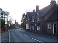
1
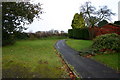
Village Footpath
This is a footpath on the very edge of Swynnerton, of a road named Fairbanks Walk.
Image: © Stephen Pearce
Taken: 1 Dec 2006
0.15 miles
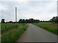
3
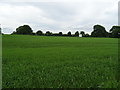
Farmland, Swynnerton
Looking towards the cricket ground from Cotes Lane.
Image: © JThomas
Taken: 1 Jun 2019
0.17 miles