IMAGES TAKEN NEAR TO
Easthead Walk, STOKE-ON-TRENT, ST1 4DZ
Introduction
This page details the photographs taken nearby to Easthead Walk, ST1 4DZ by members of the Geograph project.
The Geograph project started in 2005 with the aim of publishing, organising and preserving representative images for every square kilometre of Great Britain, Ireland and the Isle of Man.

There are currently over 7.5m images from over14,400 individuals and you can help contribute to the project by visiting https://www.geograph.org.uk
Image Map
Images are licensed for reuse under creativecommons.org/licenses/by-sa/2.0
Notes
- Clicking on the map will re-center to the selected point.
- The higher the marker number, the further away the image location is from the centre of the postcode.
Image Listing (90 Images Found)
Images are licensed for reuse under creativecommons.org/licenses/by-sa/2.0
Image
Details
Distance
1
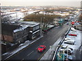
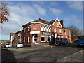
South side of Etruria Road, Hanley
View from a rather inconveniently placed room (outside the gridsquare!) in the Quality Hotel. Note the semi-derelict building in the middle right of the shot.
Image: © Ian Paterson
Taken: 10 Feb 2009
0.13 miles
2
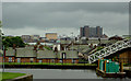
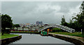
City skyline, Hanley, Stoke-on-Trent
This is a telephoto assisted image taken on a very dull morning from the Caldon Canal at Etruria.
The sharp turn of the canal to the right and under the footbridge leads immediately to the Bedford Street staircase locks. The distant buildings on the skyline are in Hanley, the pale red one beyond the nearby terraced housing (in Etruria Vale Road) being The Regent Theatre.
Image: © Roger D Kidd
Taken: 27 May 2011
0.14 miles
3
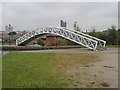
Canal Footbridge in Etruria
Just at the start of the Caldon Canal before the twin staircase locks.
Image: © Andy Beecroft
Taken: 13 Aug 2004
0.18 miles
4
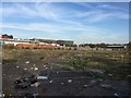
Hanley: waste ground off Clough Street
Looking towards the new Smithfield development (centre) and Tescos (left).
Image: © Jonathan Hutchins
Taken: 20 Apr 2015
0.18 miles
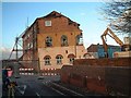
5
Robson Street, Hanley
Demolition of old pottery works on the corner of Robson Street and Slippery Lane, Hanley.
Image: © Steven Birks
Taken: Unknown
0.18 miles
6
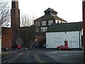
Slippery Lane, Hanley
Looking down Slippery Lane towards Sun Street.
The building with the strange top on is the remains of "Shelton Brewery" which is shown on the 1898 OS map.
Image: © Steven Birks
Taken: Unknown
0.18 miles
7
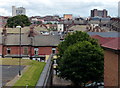
View across the city of Stoke-on-Trent
Looking east from the Etruria Footbridge across the Caldon Canal.
Image: © Mat Fascione
Taken: 11 Jul 2015
0.20 miles
8
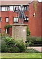
James Brindley
This statue of James Brindley is near the junction of the Trent and Mersey Canal and the Caldon Branch. He was the Chief Engineer for this canal in the latter half of the 18th. Century.
Image: © Andy Beecroft
Taken: 13 Aug 2004
0.20 miles
10
The Caldon Canal at Etruria, Stoke-on-Trent
Looks like rain! Again!
The sharp turn of the canal to the right and under the footbridge leads immediately to the Bedford Street staircase locks. The distant buildings on the skyline are in Hanley, the pale red one beyond the nearby terraced housing (in Etruria Vale Road) being The Regent Theatre.
Go compare! ;-) Image]
Image: © Roger D Kidd
Taken: 27 May 2011
0.20 miles