IMAGES TAKEN NEAR TO
Bramshall, UTTOXETER, ST14 8SQ
Introduction
This page details the photographs taken nearby to ST14 8SQ by members of the Geograph project.
The Geograph project started in 2005 with the aim of publishing, organising and preserving representative images for every square kilometre of Great Britain, Ireland and the Isle of Man.

There are currently over 7.5m images from over14,400 individuals and you can help contribute to the project by visiting https://www.geograph.org.uk
Image Map
Images are licensed for reuse under creativecommons.org/licenses/by-sa/2.0
Notes
- Clicking on the map will re-center to the selected point.
- The higher the marker number, the further away the image location is from the centre of the postcode.
Image Listing (7 Images Found)
Images are licensed for reuse under creativecommons.org/licenses/by-sa/2.0
Image
Details
Distance
1
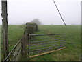
Misty Morning Path
This footpath is not that well trodden, especially not on this misty morning in October.
Image: © Michael Patterson
Taken: 18 Oct 2006
0.08 miles
2
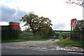
Entrance to Ashcroft Park
This is a centre for corporate and group events, team building and birthday parties. There are Quads, Archery, Rifles and Paintball events.http://www.ashcroftpark.co.uk/
Image: © Mick Malpass
Taken: 30 Oct 2011
0.09 miles
5
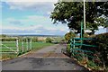
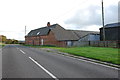
Driveway to Hayes House Farm
What a wonderful place to live, with views like this.
Image: © Mick Malpass
Taken: 30 Oct 2011
0.12 miles
6
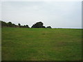
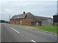
Grazing near Painley Hill Farm
Off the B5027.
Image: © JThomas
Taken: 27 Aug 2016
0.13 miles
7
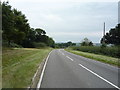
B5027 towards Uttoxeter
Heading south east.
Image: © JThomas
Taken: 27 Aug 2016
0.25 miles