IMAGES TAKEN NEAR TO
Knightslands, UTTOXETER, ST14 8PW
Introduction
This page details the photographs taken nearby to Knightslands, ST14 8PW by members of the Geograph project.
The Geograph project started in 2005 with the aim of publishing, organising and preserving representative images for every square kilometre of Great Britain, Ireland and the Isle of Man.

There are currently over 7.5m images from over14,400 individuals and you can help contribute to the project by visiting https://www.geograph.org.uk
Image Map
Images are licensed for reuse under creativecommons.org/licenses/by-sa/2.0
Notes
- Clicking on the map will re-center to the selected point.
- The higher the marker number, the further away the image location is from the centre of the postcode.
Image Listing (7 Images Found)
Images are licensed for reuse under creativecommons.org/licenses/by-sa/2.0
Image
Details
Distance
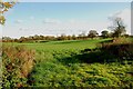
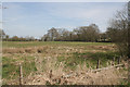
3
Footpath, stile and old seed drill near Scounslow Green
Image: © Alan Murray-Rust
Taken: 6 Apr 2007
0.18 miles
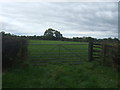
4
Quee Lane
Looking south east near Thorn Tree Farm.
Image: © JThomas
Taken: 7 Oct 2017
0.19 miles
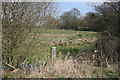
5
Moat, near Scounslow Green
Some damp depressions surrounding this field are noted on the map as an old moat. There is now no indication of any building.
Image: © Alan Murray-Rust
Taken: 6 Apr 2007
0.20 miles
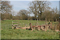
6
Moat, near Scounslow Green
Some damp depressions surrounding this field are noted on the map as an old moat. There is now no indication of any building. A small patch of open water is just visible bottom left.
Image: © Alan Murray-Rust
Taken: 6 Apr 2007
0.21 miles
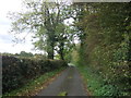
7
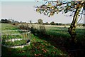
Sheep Pasture with Feeding Ring on Quee Lane
These feeding rings are used to put hay or silage in when grass is in short supply.
Image: © Mick Malpass
Taken: 6 Nov 2011
0.22 miles