IMAGES TAKEN NEAR TO
Harding Road, STOKE-ON-TRENT, ST1 3BQ
Introduction
This page details the photographs taken nearby to Harding Road, ST1 3BQ by members of the Geograph project.
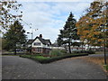
The Geograph project started in 2005 with the aim of publishing, organising and preserving representative images for every square kilometre of Great Britain, Ireland and the Isle of Man.

There are currently over 7.5m images from over14,400 individuals and you can help contribute to the project by visiting https://www.geograph.org.uk
Image Map
Images are licensed for reuse under creativecommons.org/licenses/by-sa/2.0
Notes
- Clicking on the map will re-center to the selected point.
- The higher the marker number, the further away the image location is from the centre of the postcode.
Image Listing (123 Images Found)
Images are licensed for reuse under creativecommons.org/licenses/by-sa/2.0
Image
Details
Distance
1
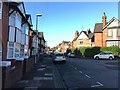
Hanley: residential street off Harding Road
Image: © Jonathan Hutchins
Taken: 5 Nov 2016
0.03 miles
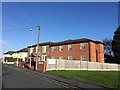
3
YMCA North Staffordshire
Website: http://ymcans.org.uk
Image: © Jonathan Hutchins
Taken: 5 Nov 2016
0.04 miles
4
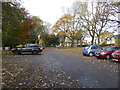
Hanley Park: car park
The North car park.
Image: © Jonathan Hutchins
Taken: 5 Nov 2016
0.05 miles
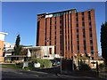
5
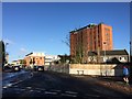
Hanley: junction of Harding Road and Matlock Street
In the foreground, Harding Road meets The Parkway. The tall building in the background is a YMCA.
Image: © Jonathan Hutchins
Taken: 5 Nov 2016
0.06 miles
6
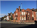
Hanley: buildings on corner of Regent Road and Shirley Road
Image: © Jonathan Hutchins
Taken: 5 Nov 2016
0.07 miles


9
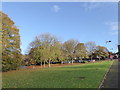
Hanley Park
Looking towards the North car park.
Image: © Jonathan Hutchins
Taken: 5 Nov 2016
0.08 miles