IMAGES TAKEN NEAR TO
Blackshaw, LEEK, ST13 8TR
Introduction
This page details the photographs taken nearby to Blackshaw, ST13 8TR by members of the Geograph project.
The Geograph project started in 2005 with the aim of publishing, organising and preserving representative images for every square kilometre of Great Britain, Ireland and the Isle of Man.

There are currently over 7.5m images from over14,400 individuals and you can help contribute to the project by visiting https://www.geograph.org.uk
Image Map
Images are licensed for reuse under creativecommons.org/licenses/by-sa/2.0
Notes
- Clicking on the map will re-center to the selected point.
- The higher the marker number, the further away the image location is from the centre of the postcode.
Image Listing (7 Images Found)
Images are licensed for reuse under creativecommons.org/licenses/by-sa/2.0
Image
Details
Distance
1
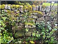
Stone Stile, Middle Hulme
A private stile on "Camping at the Hollies", looking Eastward.
The view West is Image
Image: © Jayne Tovey
Taken: 19 Oct 2023
0.01 miles
2
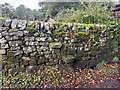
Stone Stile, Middle Hulme
A private stile on "Camping at the Hollies", looking Westward.
The view East is Image
Image: © Jayne Tovey
Taken: 19 Oct 2023
0.01 miles
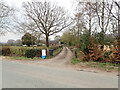
5
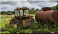
Thorn Croft
Old farm machinery in a field near Thorn Croft.
Image: © Peter McDermott
Taken: 13 Aug 2016
0.22 miles
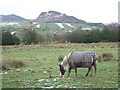
6
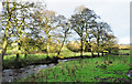
Trees beside River Churnet
The River Churnet approaching Tittesworth Reservoir which it will enter and flow through. it's also about to leave the Peak District National Park which it will do as it passes beneath the road from which the image was recorded.
Image: © Trevor Littlewood
Taken: 24 Dec 2019
0.23 miles
7
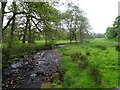
River Churnet looking upstream near Tittesworth Reservoir
Image: © John M
Taken: 27 May 2017
0.24 miles