IMAGES TAKEN NEAR TO
Blackshaw Moor, LEEK, ST13 8TL
Introduction
This page details the photographs taken nearby to ST13 8TL by members of the Geograph project.
The Geograph project started in 2005 with the aim of publishing, organising and preserving representative images for every square kilometre of Great Britain, Ireland and the Isle of Man.

There are currently over 7.5m images from over14,400 individuals and you can help contribute to the project by visiting https://www.geograph.org.uk
Image Map (Loading...)


Getting Data...Please wait
Leaflet Map data © OpenStreetMap
Images are licensed for reuse under creativecommons.org/licenses/by-sa/2.0
Notes
- Clicking on the map will re-center to the selected point.
- The higher the marker number, the further away the image location is from the centre of the postcode.
Image Listing (10 Images Found)
Images are licensed for reuse under creativecommons.org/licenses/by-sa/2.0
Image
Details
Distance
1
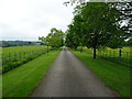
Anzio Camp
Former army camp, planned to be rebuilt as a retirement village.
Image: © Martyn Davies
Taken: 19 Feb 2006
0.02 miles
2
Entrance to Blackshaw caravan park from the A53
Image: © Steve Fareham
Taken: 16 Jul 2014
0.04 miles
3
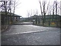
Entrance to Anzio Camp
Opened in 1943 as a transit camp for US anti-aircraft units then Polish troops and families from 1946-64. Later used as a training area until 2005. Plans for a retirement village appear to have been shelved.
Image: © John M
Taken: 28 May 2017
0.08 miles
4
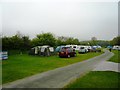
Leek Camping & Caravanning Club Site
Image: © Anthony Parkes
Taken: 24 Apr 2011
0.08 miles
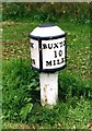
6
Blackshaw Moor milepost - detail
With the manufacturer's name (apparently William Green, Macclesfield) cast into the post, this milepost is better preserved than many along the A53. It dates from the late 19th century, and was Grade II listed https://britishlistedbuildings.co.uk/101038190-milepost-leek-2-miles-tittesworth#.Y9bdhHbP3IU & https://historicengland.org.uk/listing/the-list/list-entry/1038190 in 1985.
Image: © Richard Law
Taken: 27 Nov 2009
0.11 miles
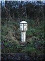
7
Old Milepost by the A53, Blackshaw Moor, Tittesworth Parish
The milestone is located by the Anzio Camp, on the verge, on the south east side of the road. Parish of Tittesworth (Staffordshire Moorlands District). Cast iron post, Green iron bobbin design, erected by the Leek & Hassop, Middlehills & Buxton turnpike trust in the 19th century.
Inscription reads:-
: LEEK / 2 / MILES : : BUXTON / 10 / MILES :
Maker:-
: WM GREEN. MACCLESFIELD :
Grade II listed. List Entry Number: 1038190
https://historicengland.org.uk/listing/the-list/list-entry/1038190
Milestone Society National ID: ST_LKBX02
Image: © J Higgins
Taken: Unknown
0.11 miles
8
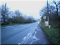
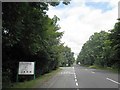
Blackshaw Moor milepost in its setting
A view along the straightest part of the A53, past Anzio Camp, with the Blackshaw Moor milepost Image in the verge on the right. This was taken on a wet afternoon and in fading light - sorry about the quality.
Image: © Richard Law
Taken: 27 Nov 2009
0.14 miles
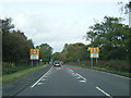
9
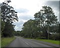
A53 south of Blackshaw Grange
A straight road (Roman alignment) looking towards a slight bend where the road crosses a small river
Image: © David Smith
Taken: 1 Sep 2017
0.17 miles