IMAGES TAKEN NEAR TO
Rudyard, LEEK, ST13 8PN
Introduction
This page details the photographs taken nearby to ST13 8PN by members of the Geograph project.
The Geograph project started in 2005 with the aim of publishing, organising and preserving representative images for every square kilometre of Great Britain, Ireland and the Isle of Man.

There are currently over 7.5m images from over14,400 individuals and you can help contribute to the project by visiting https://www.geograph.org.uk
Image Map (Loading...)


Getting Data...Please wait
Leaflet Map data © OpenStreetMap
Images are licensed for reuse under creativecommons.org/licenses/by-sa/2.0
Notes
- Clicking on the map will re-center to the selected point.
- The higher the marker number, the further away the image location is from the centre of the postcode.
Image Listing (5 Images Found)
Images are licensed for reuse under creativecommons.org/licenses/by-sa/2.0
Image
Details
Distance
1
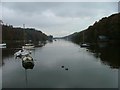
Rudyard Reservoir
Looking NW from the Dam wall
Image: © Deego
Taken: 30 Oct 2004
0.14 miles
3
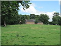
Barn near Rudyard Manor
Near the village of Rudyard.
Image: © David Weston
Taken: 15 Aug 2015
0.20 miles
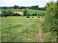
4
Field near Rudyard Manor
A view from the gate.
Image: © David Weston
Taken: 15 Aug 2015
0.23 miles
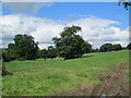
5
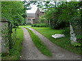
Rudyard Manor
formerly known as Green Farm.
Image: © Neil Lewin
Taken: 8 Jun 2007
0.25 miles